Download
1 / 12
120 likes | 183 Views
Fun With Google Earth. Visualization Tools. IDLE output (print) Excel (plots, charts) Google Earth (maps and marks). Communication between programs. Twitter Server your python program Over the internet local disk Your computer Excel. serializing / marshalling deserializing

E N D
Visualization Tools • IDLE output (print) • Excel (plots, charts) • Google Earth (maps and marks)
Communication between programs Twitter Server your python program Over the internet local disk Your computer Excel serializing /marshalling deserializing /unmarshalling
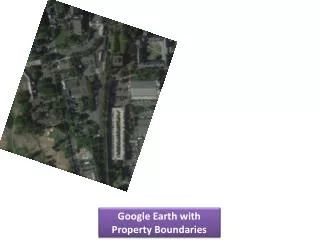
Activity 1 • Launch Google Earth • Wander around a bit, get familiar with the navigation (maybe take the built-in site-seeing tour) • Find CIT • Place a push pin • What attribute can you select for it? • Choose a proper name and description, maybe also a color • Right click on your place and save it as kml file
Activity 2 • Open your saved file using WordPad • Does it look familiar? • Can you find the information you entered? i.e., where is the name, description, coordinates, etc. stored?
Activity 3 • This is a rather completed structure. I've made a cleaned-up version, start.kml, that keeps only the essential parts. Download it and take a look using WordPad. • In Google Earth, go File->Open, and open start.kml • You should see two pins. • Go back to start.kml in WordPad. Again, make sense of what information is stored. • Can you move the first pin to another place by editing the start.kml in WordPad? • After you've made some modification In Google Earth, open start.kml again and choose 'yes' when asked whether you want to reload the file
Activity 4 • Using the modify reload paradigm, discover how much control you have over the displayed pins by modifying the content of the kml file
Base two, Base ten • All of us can count… in base ten • Base ten means that you have ten names for a single digit (i.e., 0,1,2,3,4,5,6,7,8,9), after 9, you run out of symbols, so you carry a 1 to a higher position, getting 10 ( no extra symbol needed). • How do you count in base nine? • Why base ten? • Computers use base two (binary), or base sixteen (hexadecimal) • Need to invent symbols for base sixteen