Download
1 / 19
190 likes | 289 Views
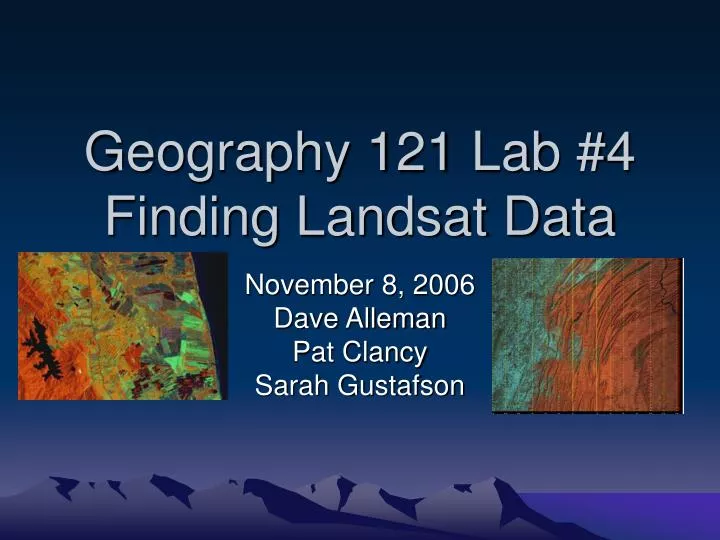
Geography 121 Lab #4 Finding Landsat Data. November 8, 2006 Dave Alleman Pat Clancy Sarah Gustafson. What are WRS Rows and Paths?.

E N D
Geography 121 Lab #4Finding Landsat Data November 8, 2006 Dave Alleman Pat Clancy Sarah Gustafson
What are WRS Rows and Paths? • WRS refers to the World Reference System, in which rows and paths create a global grid system. Path value refers to the north and south orbital path of the satellite in orbit. The row refers east and west horizontal lines similar to lines of latitude, and intersect with the paths. • There are 248 rows and 233 paths
What Is Landsat? Landsat is a joint effort between the US Geological Survey and NASA to ensure a collection of consistently calibrated earth imagery. The current satellite is the 7th satellite in the 30 year history of the project This data assists studies in global change research, agriculture, forestry, geology, resource management, geography, mapping, water quality, and oceanography
How does Landsat work? • Uses remote sensing, which involves detecting solar energy reflected off the earth. Thematic mappers on board the satellites collects the information and transfers images back to ground stations. • Think of it as “Satellite Sonar”
Landsat Image v. Browse Image • The Landsat image provides a higher resolution picture and models the actual information received by satellites about the earth. • The browse image is a model of the Landsat image, and results in less accurate representation of the Earth’s surface.
What Is ETM+ • The images we use in lab 4 are produced through Landsat 7’s Enhanced Thematic Mapper (ETM+) • This multi-spectral scanning radiometer provides image data from 8 spectral bands. ETM+ detects thermal data from the earth to assist in map creation.
The SLC Debacle • A portion of the satellite broke on May 31, 2003 which resulted in the unsightly black lines throughout the image. • The Scan Line Corrector (SLC) broke, which results in zigzag vision for the ETM • Still use the most recent images despite the lack of an SLC and the black lines.
How to create a Landsat Browse Image • Visit www.earthexplorer.usgs.gov, and enter as a “Guest”
Creating a Browse Image - Choose “Enter Place Name” - On the next screen, enter your hometown or place of interest and state, and press search
Creating a Browse Image • Select the town on the next screen, and either choose to map the point given, or a rectangle you create with your mouse of the area. • This will automatically create the geographic coordinates of your map.
Creating a Browse Image Select “Satellite Images”, and then check “Landsat 7 ETM+ (July 2003-Present)” Click “Continue”
Creating a Browse Image Select “Less than 10%” in the image cloud cover category, and “Day” in the recording technique category. If you cannot get an image at less than 10% cloud cover, make the search range wider, such as 30% cloud cover. Press Search
Creating a Browse Image • Wait as the site searches for the images. Usually takes 10 seconds • Press “Results”
Creating a Browse Image - Choose an image based upon how recent the image is and the cloud cover of the image. - Write down the Image Row, Path, and acquisition date before opening - Press “Show” for selected image
Creating a Browse Image • You may uncheck the box to turn the grid off if you prefer • Copy the image into paint and save as a bitmap file. Return to the results page.
Locating the Metadata Open the Metadata by pressing “Show” in the Show All Fields Category. Make sure you open the Metadata to the image you selected, and not a different image. Copy the Metadata from the file and paste it into a Microsoft Front Page. Then save the new page, and add a link to this page on your lab. MAKE SURE YOU SITE THE SOURCE!!! Return to the Results page
Pricing a Landsat Image • Click on the Prices link in the top left of the page.
Pricing a Landsat Image Click on USGS Landsat ETM+, or scroll down to the USGS Landsat ETM+ section. Click on Prices for the General Public, and find the cost of purchasing the image
Works Consulted • "Enhanced Thematic Mapper Plus (ETM+)." USGS Earth Resources and Observation Sciences. 22 Apr. 2006. US Geological Survey. 6 Nov. 2006 <http://edc.usgs.gov/products/satellite/landsat7.html>. • "How Does Satellite Remote Sensing Work?" 1999. Food and Agriculture Organization of the United Nations. 6 Nov. 2006 <http://www.fao.org/NEWS/1999/9911rs-e.htm>. • "Landsat 7." 14 Mar. 2006. NASA. 6 Nov. 2006 <http://science.hq.nasa.gov/missions/satellite_48.htm>. • "Landsat: a Global Land-Observing Program." Mar. 2003. US Geological Survey. 6 Nov. 2006 <http://erg.usgs.gov/isb/pubs/factsheets/fs02303.html>. • "SLC-Off Products: Background." Landsat Projects. 6 Aug. 2006. US Geological Survey. 1 Nov. 2006 <http://landsat.usgs.gov/ data_products/slc_off_data_products/slc_off_background.php>.