Download
1 / 14
140 likes | 141 Views
Learn about the GPS management structure and the role of the Civil GPS Service Interface Committee in representing civil interests, collecting user requirements, and supporting GPS authorities. Find information on the Navigation Information Service, the US States & Localities Subcommittee, and contact details for further inquiries.

E N D
Civil GPS Service Interface Committee (CGSIC) Rudy Persaud USDOT / Federal Highway Administration July 8, 2008
Outline • GPS Management Structure • Civil GPS Service Interface Committee • Relationship with the GPS Operations Center (GOC) • Navigation Information Service
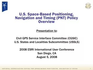
National Space-Based PNT Executive Committee(DOD/DOT Co-Chair, DOS, DOC, DHS, JCS, NASA) National PNT Coordination Office(Secretariat) DOT PNT Executive Committee DOD PNT Executive Committee DHS Geospatial PNT Executive CommitteeCo-Chairs: DHS(Preparedness) & USCG(G-51-M) Civil GPS Service InterfaceCommittee GeospatialWorking Group PNTWorking Group GPS Management Structure Defense Radionavigation Policy Civil Radionavigation Policy GPS International Working Group Primary Information Exchange With Users International Issues State Department Lead
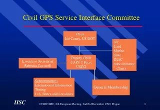
Civil GPS Service Interface Committee Chair, DOT/RITA Deputy Chair CO, NAVCEN Board Aviation Land Marine GIAC Subcommittee Chairs State Intl. Deputy Chair • Subcommittees • International • Timing • U.S. States &Localities General Membership CGSIC is the World-Wide Forum Between Civil GPS Users and U.S. Government Service Providers
Civil GPS Service Interface Committee • 700 Members: U.S. Federal, State, Non-U.S., Industry, Universities, 59 Nations • Meets once a year in plenary session • Subcommittees: • International • Timing • U.S. States and Localities
Civil GPS Service Interface Committee • Represent civil interests in GPS management and operations decisions • Collect civil user requirements for GPS • Collect information from users for GPS authorities (DOT Policy Office, GPS JPO) • Support the PNT and DOT Policy Office (OST-P)
Detailed MOA’s between each organization Established in DOT/DoD MOA, Annex 3 USCG NIS FAA NOCC USSPC GOC Joint GPS User Support Service The Core
NAVCEN Liaison to GOC • Work with DOD to safeguard civil interests in GPS satellite ops and maintenance. • Provide civil liaison to the GPS Operations Center • Coordinate issue resolution between GPS user and service provider • Support civil users in resolving outages by facilitating outage reports, coordinating resolution and findings, and disseminating results
Navigation Information Service • Disseminate Information on GPS, DGPS, Loran-C, Maritime Safety, Maritime Communications, & Local Notice to Mariners • Operational Advisory Broadcast Service • 24 Hour P.O.C. • Maintain Library of Radionav Pubs, Handbooks, Materials • 600,000 Inquiries Per Month Via Internet, E-Mail/List Server, Phone, and Mail • Collection point for GPS Outage Reporting
U.S. States & Localities Subcommittee Charter • To provide an open forum for civil user information exchange concerning the use of GPS by state and local governments within the U.S. recommending appropriate action on those issues which concern their user needs. • To identify the common needs of state and local governments for GPS information, respond to such requests and concerns submitted by this user community, and forward issues to the full CGSIC. • Identify information requirements and methods to distribute this information to state and local government users of GPS,
Charter (continued) • To maintain a list of active points of contact in state and local governments which support CGSIC activities. • To conduct state and local government GPS information studies on civil user needs. • To effectively support the CGSIC’s role under the National Positioning, Navigation, & Timing (PNT) • Executive Committee.
NAVCEN Contact Information • Navigation Information Service • http://www.navcen.uscg.gov • http://www.navcenter.org/ (mirror site) • E-mail: nisws@navcen.uscg.mil • Phone: +1 703 313 5900 • Fax: +1 703 313 5920 • Civil GPS Service Interface Committee Secretariat • E-mail: rcasswell@navcen.uscg.mil
FHWA Contact Information • Tuner-Fairbank Highway Research Center • http://www.tfhrc. gov • Rudy Persaud • E-mail: rudy.persaud@fhwa.dot.gov • Phone: +1 202 493 3391 • Fax: +1 202 493 3419 • Chair State and Local Government Subcommittee of the Civil GPS Service Interface Committee