Download
1 / 18
180 likes | 288 Views
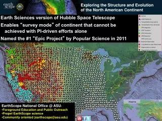
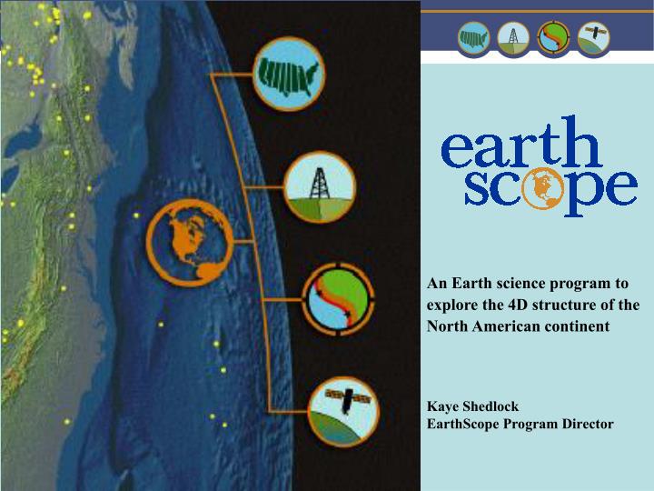
An Earth science program to explore the 4D structure of the North American continent. Kaye Shedlock EarthScope Program Director. EarthScope Program. Community Driven ESEC existing advisory structures meetings and workshops Program Solicitation Peer review Research

E N D
An Earth science program to explore the 4D structure of the North American continent Kaye Shedlock EarthScope Program Director
EarthScope Program • Community Driven • ESEC • existing advisory structures • meetings and workshops • Program Solicitation • Peer review • Research • broad, integrated studies across the Earth sciences • continental structure and evolution • large-scale continental deformation • plate boundary processes • fault properties and the earthquake process • strain transfer • magmatic and hydrous fluids in the crust and mantle • composition and structure of the deep Earth
EarthScope Program Education and Related Activities • Education and Outreach • centralized forum for Earth science education at all levels • EarthScope Education and Outreach Program • Program Solicitation • Cyberinfrastructure • integrate, distribute, and analyze diverse data sets • workshops/working groups • Program Solicitation • Facility • multi-purpose array of instruments and observatories • PBO, SAFOD, USArray
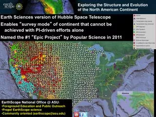
EarthScope Facility • SAFOD 3.2 km borehole into the San Andreas Fault • 875 permanent GPS stations • 175 borehole strainmeters • 5 laser strainmeters • 39 Permanent seismic stations • 400 transportable seismic stations occupying 2000 sites • 30 magneto-telluric systems • 100 campaign GPS stations • 2400 campaign seismic stations
And there’s more……… • A pool of 100 GPS receivers • and • 2400 seismic stations • 200 broadband • 200 short-period • 2000 single-channel active source • will also be available for PI-funded experiments.
EarthScope Facility Current Status 8/13/2005
Program Solicitation • 04-589 (revised) • July 16, 2005 (annually) • June/July for joint submissions with core science programs • interdisciplinary, collaborative projects • workshops • “development” projects • CAREER • cyberinfrastructure
Revisions to NSF 04-589 • Updated program description • $ 4.5 million for FY2006 • EarthScope/NEES Research Opportunities • Research requiring coordinated use of both facilities • NEESR 05-527; March 11, 2006 deadline; co-reviewed • EarthScope Imagery and Geochronology • Acquisition of aerial and satellite imagery and geochronology that extend the time scales available from PBO geodetic instrumentation • Indicate how imagery or geochronology will contribute to the success of EarthScope • Helpful hint: read and adhere to the Grant Proposal Guide, 04-23
107 proposals requesting a total of $ 32,412,801 46% collaborative proposals (27/58) 57 projects reviewed by panel E&O - 2 PBO - 9 Integrated - 19 SAFOD - 10 USArray - 18 3 workshops proposed National meeting proposed 13 projects funded to date E&O - 0 PBO - 3 Integrated - 3 SAFOD - 3 USArray - 4 54% collaborative proposals (7/13) to date National meeting supported 2 workshops supported ~ $ 3.8 million awarded to date Second Solicitation - FY05
Examples of Projects • PBO • PBO Nucleus • Making Effective Use of GPS and Strainmeter Data: A PBO Pilot Project • Interdisciplinary • Imaging the Deep Roots of the San Andreas Fault • Developing a Methodology for Imaging Imaging Stress Transients at Seismogenic Depths • SAFOD • Targeting the Phase III SAFOD Drilling • Fluid Transport Analysis - Rare Gas “Ages” of Matrix Porosity Fluids in Drill Core • USArray • Lithospheric Foundering Beneath the Sierra Nevada • Seismic Observations from the Random Wavefield: A New Tool for High-Resolution Seismology in the Context of EarthScope
Scientific Questions • 4D plate boundary behavior • 4D continental evolution • Spatial and temporal scales of deformation • Lithospheric composition/strength profile • Balanced, timely, “complete” characterization of the SAFOD volume, including earthquake locations • PBO design and full utilization • Geotraverse versus smaller interdisciplinary efforts • Development of integrated data analyses • Identification/development of new science education tools/modules and scientific products • Imagery and geochronology • Cyberinfrastructure
EarthScope Science San Andreas Fault Observatory at Depth (SAFOD) • In August, 2005, EarthScope successfully drilled across the San Andreas Fault • from the Pacific to the North American Plate at a depth of about 2 miles, • in an area of active earthquake generation. • Data collection continues: • retrieval of fault zone rock and fluids for laboratory analyses during drilling • intensive downhole geophysical measurements in all phases • post-drilling, instrumentation installed to record • pore pressure, temperature, and strain during the earthquake cycle • observations of earthquake nucleation and rupture • Fundamental scientific questions that SAFOD data and observations will address: • how and why plate boundary faults lose their strength • where plate boundaries form • how plate boundaries evolve • how deformation is partitioned along plate boundaries
Fault Contact at 10,063 ft Highly Deformed Siltsone Clay Gouge Granite Cobble Conglomerate 2.5 cm
Upcoming Meetings • Geological Society of America Annual MeetingSession T141: Geology and EarthScope October 16, 2005; Salt Lake City, UT • American Geophysical Union Fall MeetingSession T02: The Elusive Subcontinental Mantle: Its History, Deformation, and Anisotropy December 5-9, 2005; San Francisco, CA • American Geophysical Union Fall MeetingSession T11: The San Andreas Fault Observatory at Depth (SAFOD) December 5-9, 2005; San Francisco, CA • American Geophysical Union Fall MeetingSession T27: Hubbert and Rubey in the 21st Century: Constraints on Pore Pressure in Fault Zones From Field, Laboratory, and Modeling Studies December 5-9, 2005; San Francisco, CA • American Geophysical Union Fall MeetingSession ED02: Integrating Education and Outreach with Large-Scale Experiments December 5-9, 2005; San Francisco, CA
EarthScope Data • EarthScope Annual Data Volume • Data volumes over next 10 years • GPS: ~7.7 TB • BSM/LSM: ~10.5 TB • Seismic: ~120 TB
EarthScope Education and Outreach EarthScope Education and Outreach