Download
1 / 49
520 likes | 782 Views
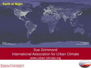
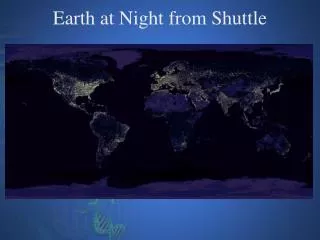
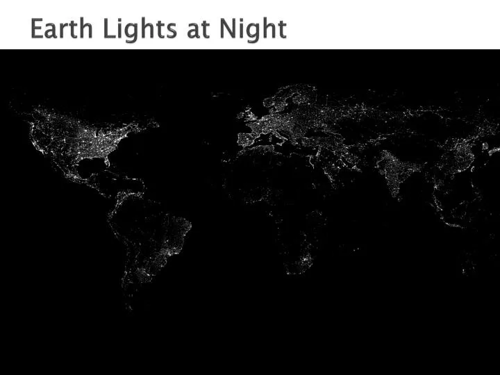
Earth Lights at Night. What else can you see? . Canada's population is almost exclusively along the US border. There is a high population concentration along the Mediterranean Coast. It's easy to spot London, Paris, Stockholm and Vienna.

E N D
What else can you see? • Canada's population is almost exclusively along the US border. • There is a high population concentration along the Mediterranean Coast. It's easy to spot London, Paris, Stockholm and Vienna. • Note the Nile River and the rest of the "Dark Continent." After the Nile, significant lights don't come on again until Johannesburg. • Look at the Australian Outback and the Trans-Siberian Rail Route. • Note the difference between North and South Korea. • Note the density of India and Japan. This is what the Earth looks like at night. Can you find your favorite country or city? Surprisingly, city lights make this task quite possible. Human-made lights highlight particularly developed or populated areas of the Earth's surface, including the seaboards of Europe, the eastern United States, and Japan. Many large cities are located near rivers or oceans so that they can exchange goods cheaply by boat. Particularly dark areas include the central parts of South America, Africa, Asia, and Australia. The above image is actually a composite of hundreds of pictures made by orbiting satellites.
Human-Environment Interaction: The study of the interrelationship between people and their physical environment.
Two Important Questions? 1. How Does the EnvironmentInfluence Human Behavior? 2. How Do Humans Influence Their Environment?
Why study Human-Environment Interaction? By understanding how the Earth’s physical features and processes shape and are shaped by human activity, geographers help societies make informed decisions.
How Does the EnvironmentInfluence Human Behavior: • Settlement patterns • Housing materials • Agricultural activity • Recreational activity • Transportation patterns
How Do Humans Influence Their Environment? How do people use their environment, how and why do they change it, and what consequences result from these changes? Examples: • Diverting water: dams, canals, polders • Changing the landscape: terrace farming, deforestation, desertification • Changing the environment: acid rain, pollution
Aswan High Dam FACTS: Built 1979 Control Flooding Nile River Aswan, Egypt Lake Nasser
Helped with Irrigation Decreased soil fertility
Aral Sea FACTS: Central Asia Uzbekistan Kazakhstan Formerly USSR: Diverted water to grow cotton/rice
Disappearing waters and poisonous runoff from the fields have caused the sea to shrink and increased desertification.
Colorado River FACTS: 1450 miles Through SW U.S. and NW Mexico Source – Rocky Mtns. Mouth – Gulf of California
More than 20 dams Water diverted to the Imperial Valley No longer reaches the Gulf of California
Polders in the Netherlands FACTS: Northern Europe Most of the country is below sea level Sea walls/dunes protect it from the sea.
Deforestation Brazil – SA Nepal – Asia Malaysia - Asia Rainforest FACTS: Contain more than ½ the world's 10 million species of plants, animals and insects One-fifth of the world's fresh water 20 percent of the world oxygen
Once covered 14 % of earth. Now cover 6% 1-1/2 acres lost every minute
Desertification Greatest Areas of Impact Africa – Sahara Desert Asia – Gobi Desert Central Asia SW United States
CAUSES: Overgrazing Drought Poor Farming Techniques Overpopulation Natural Climate Patterns
Acid Rain Given the causes, where might you find acid rain the most?
Acid Rain Developed Countries: US, Europe, China
Coniferous forests in the Appalachian Mountains destroyed by acid rain.
Pollution AIR
Most Polluted Cities: • Mexico City, Mexico • Buenos Aires, Argentina • Beijing, China • Cairo, Egypt • Seoul, South Korea • Karachi, Pakistan • Jakarta, Indonesia • Los Angeles, California USA
Mexico City Mexico City reports unhealthy ozone emissions nearly 85% of the year. Mexico's geographical location--in the center of a volcanic crater and surrounded by mountains-- locks in the air pollution, causing smog to sit above the city.
Chernobyl, Ukraine - Chernobyl is now infamous for the 1986 nuclear disaster that killed 30 people, forced 35,000 to evacuate their homes, and left a 19-mile radius around the plant that is still uninhabitable to this day.