Download
1 / 24
240 likes | 357 Views
Climatic Perspective on the fall/winter of 2004-2005. Nathan Mantua, Ph.D. University of Washington Climate Impacts Group http://cses.washington.edu/cig March 21st, 2005 -- Washington Water outlook. The good news. The winter of 2004-05 has finally ended! It’s been snowing in the Cascades.

E N D
Climatic Perspective on the fall/winter of 2004-2005 Nathan Mantua, Ph.D. University of Washington Climate Impacts Group http://cses.washington.edu/cig March 21st, 2005 -- Washington Water outlook
The good news • The winter of 2004-05 has finally ended! • It’s been snowing in the Cascades From the Mt Baker ski area web-cam (10 am, Sunday March 20th)
outline • Where are we? • How and why did we get here? • Where do we appear to be going in the next few months?
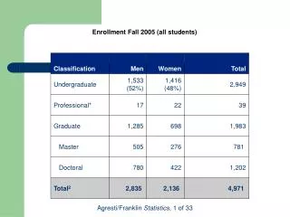
Where are we? (climatologically speaking) • In a lousy snowpack situation - current snow-water for the Washington Cascades ranges from 13% for the Cedar/Tolt/Green to 44% for the Columbia R. above the Methow
How did we get here? • the low snowpack occurred largely because of warm temperatures during the periods when most of our precipitation occurred: December 6-10 and January 17-19
76% • Fall and winter storms have generally been too warm to develop this year’s snowpack 35%
73% • White-Green-Puyallup: swe-23%, pcp 53% • Cedar-Snoqualmie-Skykomish Tolt: swe-13%, pcp 64% • Baker-Skagit-Nooksack: swe-23%, pcp 77% 19%
seasonal averages of precipitation and temperature are not exceptional. Most locations in Washington have received 65-80% of normal precipitation since October 1. This is considerably more than in 1977 or 2001. Temperatures also have been only about 1F above normal. Precip % of normal since Oct 1
Los Angeles got almost twice as much rainfall as Seattle (~25" versus ~17") since October 1!
Jet stream wind patterns Why? R • The proximate cause was a large number of days with a split jet stream around a blocking ridge located over the NW region • Was it El Niño? • Definitely not “typical” of past El Niño events Ocean temperature anomalies
Oct 2004-Feb 2005 200mb ht anomalies The tropical atmosphere has been warm!
Are we in a situation like the early 1990s with multiyear warmth in the western eq. Pacific?
Oct-Mar 91-95 200mb ht anoms Oct-Mar 02-05 200mb ht anoms
Oct-Mar 91-95 SST anoms Oct-Mar 2002-05 SST anoms
\ From NCDC’s 2004 Annual Climate Report http://www.ncdc.noaa.gov
What’s next? • NOAA’s Climate Prediction Center calls for increased odds for above average spring (AMJ) temperatures, and climatological odds for precipitation (forecast issued March 17th) Temperature Precipitation
What’s next? (another view) • The International Research Institute for Climate Prediction (iri.columbia.edu) also predicts a tilt in the odds favoring a warm spring (AMJ)
summary • It has been a warm and dry winter, but not of “record” extremes in either temperature or precipitation • The tropics have been very warm, yet not in a “classic” El Niño pattern • part of longer term and broader scale atmospheric warming? • Official CPC forecast calls for increased odds for a warm spring
CPC forecast for July-August-September 2005 Temperature Precipitation