Download
1 / 19
190 likes | 298 Views
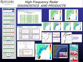
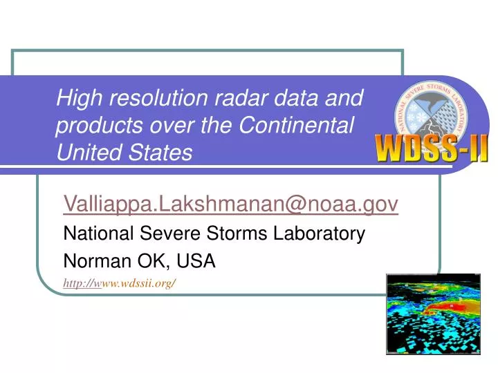
High resolution radar data and products over the Continental United States. Valliappa.Lakshmanan@noaa.gov National Severe Storms Laboratory Norman OK, USA http://w ww.wdssii.org/. Evolution of WDSS. What products? How often?. Products: Gridded hail products

E N D
High resolution radar data and products over the Continental United States Valliappa.Lakshmanan@noaa.gov National Severe Storms Laboratory Norman OK, USA http://www.wdssii.org/
Evolution of WDSS lakshman@ou.edu
What products? How often? • Products: • Gridded hail products • Reflectivity at constant temperature levels and layer averages • Low-level and mid-level shear and rotation tracks • Short-term forecast fields • Lightning Density • More … • Spatial Resolution: • 0.01 deg x 0.01 deg [x 1km] resolution • Approximately 1km x 1km throughout Continental United States. • 1km in height • Temporal resolution: • 2D reflectivity mosaics every 2 minutes • 3D and derived products every 5 minutes lakshman@ou.edu
How does it work? • The process for creating 2D composites: • Ingest Level-II radar data tilt by tilt • QC reflectivity data (Lak06, JAM, review) • Create virtual volume composites • Merge composites from all the CONUS radars (Lak06, WF, accepted) • 2nd level of QC -- using satellite and surface temperature data. lakshman@ou.edu
Virtual volume composite • In a traditional composite, • Process volume-by-volume. • Take maximum of all tilts. • Need to wait for end of volume. • In a virtual volume composite: • Process tilt-by-tilt. • Keep a running volume. • Replace older data each time. • Take maximum of most current tilts. • No need to wait for end of volume scan. • A virtual volume provides more timely data. at19.5 at0.5 lakshman@ou.edu
Why do QC? • On a single-radar product, users may: • want to see clear-air returns. • tolerate more clutter • tolerate test patterns, etc. • On a multi-radar product, clutter and clear-air returns are distracting. lakshman@ou.edu
Impact of QC raw With QC’ed composites • Left: What we would get if directly combined raw (virtual volume) reflectivity composite data • Clear-air return, sun strobes, test patterns • Right: combining QCed virtual volume reflectivity composite • The QC is performed radar-by-radar • Takes into account terrain, texture and vertical structure. lakshman@ou.edu
Second level of QC • The radar QC is conservative • Doesn’t always remove non-precipitation echo • Especially if it is biological i.e. moving. • A second level of QC looks at satellite and surface temperature and retains echo where there is likely to be clouds. Bad data (bloom) No clouds lakshman@ou.edu
What do we do with the composite? • The 2D radar mosaic is created every 2 minutes at 1km resolution. • Converted to Grib2 and sent to the SPC. • Put on the Internet: • Snapshots with map background • Converted to Geotiff • Loadable with Google Earth or any GIS software. • Google Earth does real-time loading • Talk in IIPS on Tuesday • http://wdssii.nssl.noaa.gov • Not 24x7 • The software is licensed by some private companies • They run it on their own machines. • They take care of 24x7 reliability. lakshman@ou.edu
2D vs 3D • The 2D composite is cheap to create • 5 dual-Xeon machines with 6 GB RAM • But always provides an underestimate of true values. • Need to compute in 3D • Height of dBZ value important! • Can incorporate NSE information by height • A lot more products! • The 3D products need: • 5 dual-Xeon with 6 GB RAM • 2 dual-Xeon with 16 GB RAM • 64-bit architecture composite from 2D: 45 dBZ composite from 3D: 50 dBZ lakshman@ou.edu
The 3D flow • Not just reflectivity. • Compute shear (Smith05) and low-level shear. • Process lightning lakshman@ou.edu
3D processing • Combine QC’ed reflectivity in 3D • Combine AzShear in 3D • Compute hail diagnosis and layer averages. • Compute storm motion from composite. • Use it to advect storms for short-term forecast. lakshman@ou.edu
Example products • Extracted from the real-time generation on Jan. 11, 2006 • The day I created this presentation! • We haven’t run the CONUS system in Spring yet, so the severe weather products may be underwhelming. lakshman@ou.edu
Reflectivity products Composite from 2D Composite from 3D Which radars? Height of Max Ref lakshman@ou.edu
Azimuthal shear products 30 minute rotation tracks Azimuthal shear 0-3km MSL lakshman@ou.edu
Severe weather diagnosis Also: Probability of Severe Hail Maximum Expected Hail Size VIL_Density VIL_of_the_day Other echo top dBZ levels Reflectivity at temp. levels VIL Convection Echo top (18 dBZ) lakshman@ou.edu
Short-term forecast Reflectivity at T=0 Clusters Southward motion Reflectivity at T=30 (forecast) lakshman@ou.edu
Precipitation estimates Instantaneous precip rate Ref closest to ground • Just the 88D algorithm on CONUS • Uses hybrid scan reflectivity • Convective/stratiform segregration based on presence of hail • 88D Z/R relationships. • Not multi-sensor • QPESUMS-II under development at NSSL. 2hr precip accum lakshman@ou.edu
What do we do with these products? • The 3D products are created every 5 minutes • 1km resolution (0.01deg x 0.01deg x 1km) • Converted to Grib2 and sent to the SPC. • Put on the Internet (not all of them): • Snapshots with map background • Converted to Geotiff • Loadable with Google Earth or any GIS software. • Google Earth does real-time loading • Talk in IIPS on Tuesday • http://wdssii.nssl.noaa.gov • Looking for the NWS to pick this up! lakshman@ou.edu