Download
1 / 18
180 likes | 277 Views
NOAA SS Viz Outline. ArcMap to Maya (+ Shake) Animating a Better Surge in Maya. Questions for ArcMap to Maya. What files do we need from ArcMap? How are these files going to be used? What limitations do the RGB & Z files have? Geospatial vs Artistic License?.

E N D
NOAA SS Viz Outline • ArcMap to Maya (+ Shake) • Animating a Better Surge in Maya
Questions for ArcMap to Maya • What files do we need from ArcMap? • How are these files going to be used? • What limitations do the RGB & Z files have? • Geospatial vs Artistic License?
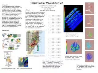
The first step in this process is to isolate the area we are planning on demonstrating. Hurricane Ivan affected the two Alabama counties and four Florida counties below.
After isolating the specific area, the next step is to obtain the DEM in a raster format. The DEM below was exported at 96 DPI into a grayscale TIFF. For demonstrative purposes this file was extruded @ 96 dpi as a TIFF. This file was then edited so it is 1024 pixels square.
A satellite raster is also exported with the same exact spatial scope. This file texture will be projected onto the extruded polygon. For demonstrative purposes this file was extruded @ 96 dpi as a TIFF. This TIFF was then edited in Photoshop so it is 1024 pixels square.
Once the DEM and RGB TIFFs have been obtained, the DEM is applied to a polygon plane (bottom) as a displacement map. The grayscale range of the displacement map is then referenced to used to build 3D polygon of DEM TIFF.
The bottom polygon in this screen grab is a 2D plane with the DEM as a texture map. The top has been extruded into a 3D shape.
Once the top has been extruded, the Vertical (Y) scale must be adjusted. In this example, the ScaleY is increased by a factor of 10. This is done so the water level change can be animated without any fear of occlusion.
In this image, the RGB raster is applied as a texture to the extruded polygon. Because the RGB and DEM images were aligned within ArcMap, we don’t have to worry about changing the projection of the RGB image.
Now that the Land has been developed, the next step is to introduce the water special fx. Below you see the NURBS circle which represents the water plane. The bounding box behind the circle shows the scope of the environmental fog. In this case, a blue haze.
This image was rendered in 2 minutes with Mental Ray. The Maya render farm software which uses 8 CPUs. Notice the reflection of the hills in the waves. This is a software effect and is the main reason entire renders take so long.
This is the same data with a water level much higher than the prior image. Notice the black squares in the top left. These blocks result when render satellites drop data when transferring the render data from one computer to another.
The last step is to place the camera for animation. Its initial location is near the south west point of this data.
The final location of the camera is the eastern edge of this data set. After setting the animation path, the last step is to render. In this example, the time difference between the foreground location and background location is 100 frames or 3 seconds.
New Approach - ArcGIS • Need Land Boundary • Storm Surge Levels (no surge + 5 surge levels) • DEM Data • large scale/low detail && (202 miles2) • small scale/high detail (1 km2 ?) • Road Layouts & housing lots for small scale/high detail material
New Approach - Maya • Wind Vectors via Dynamics • Surge Muscle Surge via Dynamics • Multipass Rendering • 1st pass, geometry • 2nd pass, water • 3rd pass, dynamics • This keeps us from having to do one massive render with all material. • Requires compositing software. • Allows for hardware and software strengths to compliment each other. • Easy to go back and fix problems or add more geometry… (houses, trees, etc) without having to re-render EVERYTHING. • Multi-modeling. Have Kyle/Kristin/Sean…. put together a few house, car, etc models I can then use in the render as well.
New Approach – Shake (compositing) • 5 Surge Levels (+1 for tide level) • Shake allows me to make a smooth transition for the water level increase • Gives us the gradual and more realistic transition during the surge progression. • Allows me to piece together multipass renders. I can easily go back, rerender something and add it back to the compositing stack.