Download

1 / 33
330 likes | 913 Views
Global Positioning Systems (GPS) When GPS goes awry Globe and Mail, Oct 7 2010 http://sheepfilms.co.uk/2009/09/15/gps/ Satellites launched 1989-1994 Initially designed to pinpoint locations and reduce civilian casualties What is GPS ? The Global Positioning System

E N D
When GPS goes awry Globe and Mail, Oct 7 2010 http://sheepfilms.co.uk/2009/09/15/gps/
Satellites launched 1989-1994 Initially designed to pinpoint locations and reduce civilian casualties
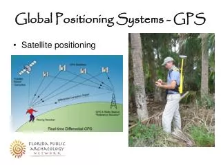
What is GPS ? • The Global Positioning System • … a satellite-based navigation system consisting of a network of 24 • orbiting satellites that transmit radio signals to GPS receivers. • The system consist of 3 ‘segments’: • Space segment • Control Segment • User segment
1. Space segment: Satellite Constellation GPS is the US system Russia has GLONASS Europe plans Galileo (2014) 24 satellites at 20,000 km altitude, at 55 degree angle to equator (Glonass = 65)
2. Control segment: ground stations These 5 stations monitor the GPS satellites, check their operational health and exact position in space. The master ground station transmits corrections for the satellite's ephemeris constants and clock offsets back to the satellites
3. User segment: GPS receiver and antennas Handheld recreation grade units 5-15 m Resource grade units 1-5 m Survey grade units 1 cm
GPS Trilateration Distance = Time x Speed (Speed = 300,000 km/sec) Atomic clocks measure time in seconds to 10 decimal places • Code is transmitted many thousand times a second and includes • Time: • Which satellite it is • XYZ coordinates (ephemeris)
4 satellites are needed for accurate location (3 if only 2D) 4 time measurements correspond with 4 ‘pseudo-ranges’ (distances)
Process: • 1. Satellite sends out signal/code e.g. at midnight (with date stamp) • 2. GPS units receives code at midnight plus travel time (decimal seconds) • 3. The delay or lag when the GPS receives it is the signal’s travel time. • 4. GPS unit multiplies the time by the speed of light to determine how far the signal travelled = how far you are from that point in space • 5. Software combines the >4 readings to generate a ground location • (with some degree of error)
What are the sources of error? Errors (approximate) Ionosphere 4.0 metresClock 2.1 mEphemeris 2.1 mTroposphere 0.7 mReceiver 0.5 mMultipath 1.0 mTotal 10.4 m
Selective Availability • The random error, added to GPS signals before 2000 • up to 100 metres error by scrambling last 3 decimals • Turned off May 1, 2000 at midnight • No intent to ever use it again
May 3, 2000 – Selective Availability Off May 1, 2000 – Selective Availability on
Uncorrected GPS ~10m Corrected (DGPS) ~1m Differential Correction
Dilution of Precision PDOP < 8.0 acceptable PDOP < 4.0 : excellent DOP is an indicator of the quality of the geometry of the satellites High DOP (poor) Low DOP (good)
GPS vertical accuracy = ~ 2x horizontal errorGPS units may also have built-in barometer for heights
Environmental Factors Generally, GPS is unaffected by weather Heavy rain can weaken the signal Wet foliage impacts more than dry foliage Humidity and Temperature – no effect Wind may have positive effect under forest canopy
Wide Area Augmentation System - WAASEGNOS (European Geostationary Navigation Overlay Service) • Network of 25 land based stations that send correction data to the satellites which in turn relay this data to our handheld GPS units • In good conditions can improve accuracy to 2-4 m • Almost all new GPS units sold are WAAS enabled • WAAS improves accuracy by correcting for errors in the satellite's clock and orbit, and for ionospheric errors.
POR #47 3F3 Pacific Ocean at 178.0°E@AOR-W #35 3F4 Pacific Ocean at 142.0°W@PanAm #48 Galaxy 15 Pacific Ocean at 133.0°W*Anik #51 F1R Pacific Ocean at 107.3°W* WAAS Satellites - Geostationary
Recreation Grade: hiking, boating, hunting $100-500 • No differential correction • No Setting of mask angle • No setting of PDOP collection values • Tracks only one frequency or signal • No ability to reject multi-path measurements • Resource/ Mapping Grade: sub-metre accuracy $5,000 – 10,000 • -Differential correction – post processing or real time • -Setting mask angles • PDOP value collection • Ability to reject multi-path measurements • Survey Grade: cms accuracy $20,000- 50,000 • All of above plus: • Tracking two frequencies Types of GPS units and errors
GPS wildlife collars- monitor movements to minimise conflicts between predictable bears and unpredictable humans
Measuring Glacier thickness with GPS UNBC Ph.D student Matt Beedlemeasures changes in the glacier’s elevation due to ice melt and flowA month ago, a pole in the glacier with only a few millimeters showing at the top was now exposed to nearly his height. Using GPS equipment that can measure his elevation on the glacier within a centimetre, Beedle was able to confirm that the thickness of the glacier at that point had dropped more than 1.5 metres through the month of August alone.Matt also ski’s down the glacier collecting RTK (Real-time kinetic) data
Galileo Positioning System • European Space Agency (ESA) alternative • 30 satellites on 3 orbital planes • 27 countries involved • Major delays plaguing system • Fully operational by 2014 • Compatible with GPS (U.S.) • Clocks 10 times more accurate than GPS clocks Other Satellite Systems • GLONASS • Russia’s counterpart is the US Global Positioning System (GPS) • 21 satellites on 3 orbital paths • Magellan and Trimble sell units that can utilize GLONASS signals • Moving towards compatibility with US and EU systems
Some GPS sites: www.garmin.com Geocaching BC lighthouses www.gpsdrawing.com