Download
1 / 13
210 likes | 1.32k Views
Lecture 4 Geographic Coordinate System. Md. Mahbubul Alam , PhD Dept. of AEIS, SAU. Intended Learning Outcomes (ILOs). Geodesy-The Shape of the Earth Datum Geographic Coordinate Systems Projected Coordinate Systems Discuss how datum, coordinate systems, and central meridian work.

E N D
Lecture 4Geographic Coordinate System Md. MahbubulAlam, PhD Dept. of AEIS, SAU
Intended Learning Outcomes (ILOs) • Geodesy-The Shape of the Earth • Datum • Geographic Coordinate Systems • Projected Coordinate Systems • Discuss how datum, coordinate systems, and central meridian work Prepared by Md Mahbubul Alam, PhD
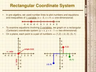
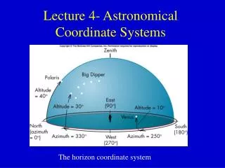
Coordinate Systems: Basics • Meridians: • Converge at poles • Consistent angle apart • Longitude • Parallels: • Fixed distance apart • Never converge • Latitude Coordinate systems provide a basis for identifying locations on the earth’s surface Prepared by Md Mahbubul Alam, PhD
Why Projection Systems Required? • Projected data from a spheroidal shape to a flat plane. • Defines the range of valid X and Y properties of geometries. • Data often comes in geographic, or spherical coordinates (latitude & longitude) and can’t be used for area calculations in most GIS software applications. Prepared by Md Mahbubul Alam, PhD
Coordinate System • Geographic Coordinate System (GCS) • A set of points, lines and/or surfaces, and a set of rules, used to define the positions of points in space, in either two or three dimensions, • A geographic coordinate system definition includes a datum, prime meridian, and angular unit of measurement. • It uses angular units defining coordinates in terms of latitude and longitude, which are angles calculated from the centre of the earth describing a position on its surface. • Calculations based on spheroidal model of the earth are sometimes known as geodesic or geodetic. • Projected Coordinate System (PCS) • A system that used to locate x,y, and z positions of point, line, and area features on a flat, two-dimensional surface. • Unlike GCS, a PCS has constant lengths, angles & area across two dimension. • A PCS is always based on a GCS. In addition it includes a map projection, a set of projection parameters that customize a map for a particular location, and a linear unit of measure. • e.g., UTM=> Universal Transverse Mercator Prepared by Md Mahbubul Alam, PhD
CoordinateSystem: Explained • A point is referenced by its longitude and latitude values. • Longitude and latitude are angles measured from the earth’s centre to a point on the earth’s surface. • Angles are often measured in degrees (or in grade). • Horizontal lines, or east–west lines, are lines of equal latitude, or parallels. • Vertical lines, or north–south lines, are lines of equal longitude, or meridians. These lines encompass the globe and form a gridded network called a graticule. • The line of latitude midway between the poles is called the equator. It defines the line of zero latitude. • The line of zero longitude is called the prime meridian. For most GCSs, the prime meridian is the longitude that passes through Greenwich, England. The origin of the graticule (0,0) is defined by where the equator and prime meridian intersect. • Latitude and longitude values are traditionally measured either in decimal degrees or in degrees, minutes, and seconds (DMS). • Latitude values are measured relative to the equator and range from –90° at the south pole to +90° at the north pole. Longitude values are measured relative to the prime meridian. They range from –180° when traveling west to 180° when traveling east. • It may be helpful to equate longitude values with x and latitude values with y. Prepared by Md Mahbubul Alam, PhD
Geographic (Datum) transformations • “Known locations to which we reference geographic information” • A datum is a model of the earth that is used in mapping. • In case of two datasets are not referenced to the same geographic coordinate system, it is required to perform a geographic (datum) transformation. • The datum consists of a series of numbers that define the shape and size of the ellipsoid and it’s orientation in space. • A well-defined mathematical method to convert coordinates between two geographic coordinate systems. • There are several hundred predefined geographic transformations that can access. • A datum is chosen to give the best possible fit to the true shape of the Earth. Prepared by Md Mahbubul Alam, PhD
Datum • A datum in general is a reference points, surface or baseline from which measurement are made. • Datum is used for geodesy navigation and surveying by cartographers and satellite navigation. • A system to translate position indicated on maps to their real position on earth. • Each starts with an ellipsoid and then defines latitude, longitude and altitude coordinates. • One or more locations on the earth surface are chosen based on points. Prepared by Md Mahbubul Alam, PhD
Types of DATUM Horizontal Datum • Horizontal datum is the one that use in measuring a specific position on the earth’s surface in coordinate system such as latitude and longitude. • Because of the different local datum, the same position can have many different geographic coordinates so it is important to know which datum the references is in. • It is a collection of specific points on the Earth’s surface that have been accurately identified according to their latitude and longitude. • To create the network of horizontal positions, surveyors marked each of the positions they had identified with brass, bronze or aluminum disk known as survey benchmark. Prepared by Md Mahbubul Alam, PhD
Types of DATUM (cont’d) Vertical Datum • Vertical datum is the measurement of the elevations of specific points on the earth. • Without a common datum, surveyors would calculate different elevation values for the same location. • A reference surface is mean sea level. • Two types: • Tidal datum=> interface between water and land, defined by the tidal variation. • Geodetic datum=> Reference surface of zero elevation to which height are referred to over a large geographic area. It is a tool to used to define the shape and size of the earth. • With mean sea level as a reference points of zero, it is possible to measure height or topography accurately. Prepared by Md Mahbubul Alam, PhD
Common Datum • The most common spheroid was Clarke 1866, the North American Datum of 1927 (NAD27) is based on that Spheroid, and has its center in Kansas. • A newer, satellite measured spheroid is the World Geodetic System 1984 (WGS84) spheroid, which is more or less identical to Geodetic Reference System 1980 (GRS80). • The GPS system uses WGS84. • WGS84 is considered to be a datum and a spheroid. Prepared by Md Mahbubul Alam, PhD
Geodetic Datum and Projections used in Bangladesh • Gulshan 303, a geodetic datum first defined in 1995 referred to the Everest 1830 ellipsoid and the Greenwich Prime Meridian. • Everest Bangladesh • WGS84 Prepared by Md Mahbubul Alam, PhD
Acknowledgements • http://resources.esri.com/help/9.3/arcgisengine/dotnet/89b720a5-7339-44b0-8b58-0f5bf2843393.htm • https://www.coursera.org/lecture/spatial-analysis/geographic-coordinate-systems-AQ2Qr • https://www.youtube.com/watch?v=LTU00GWGapw Prepared by Md Mahbubul Alam, PhD