Download
1 / 25
310 likes | 1.17k Views
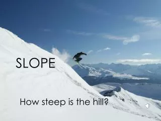
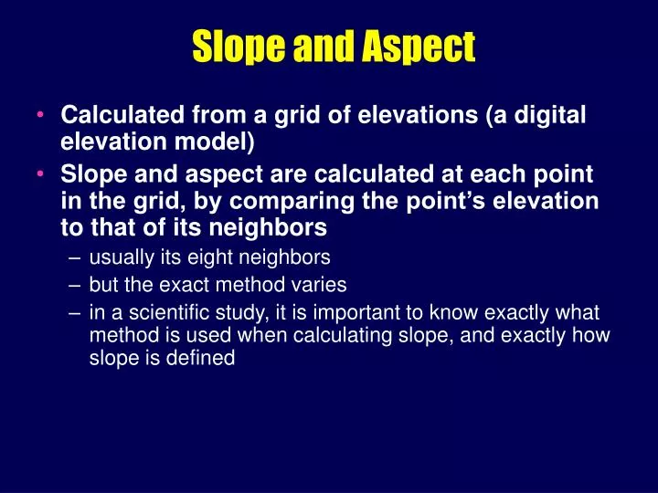
Slope and Aspect. Calculated from a grid of elevations (a digital elevation model) Slope and aspect are calculated at each point in the grid, by comparing the point’s elevation to that of its neighbors usually its eight neighbors but the exact method varies

E N D
Slope and Aspect • Calculated from a grid of elevations (a digital elevation model) • Slope and aspect are calculated at each point in the grid, by comparing the point’s elevation to that of its neighbors • usually its eight neighbors • but the exact method varies • in a scientific study, it is important to know exactly what method is used when calculating slope, and exactly how slope is defined
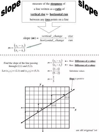
Slope Definitions • Slope defined as an angle • … or rise over horizontal run • … or rise over actual run • various methods • important to know how your favorite GIS calculates slope
1 2 3 4 5 6 7 8 9 Slope and Aspect • measured from an elevation or bathymetry raster • compare elevations of points in a 3x3 neighborhood • slope and aspect at one point estimated from elevations of it and surrounding 8 points • number points row by row, from top left from 1 to 9
1 2 3 4 5 6 7 8 9 Typical Slope Calculation • tan (slope) = sqrt (b2 + c2) • b = (z3 + 2z6 + z9 - z1 - 2z4 - z7) / 8D • c = (z1 + 2z2 + z3 - z7 - 2z8 - z9) / 8D • b denotes slope in the x direction • c denotes slope in the y direction • D is the spacing of points (30 m) • find the slope that fits best to the 9 elevations • minimizes the total of squared differences between point elevation and the fitted slope • weighting four closer neighbors higher
1 2 3 4 5 6 7 8 9 Aspect • tan (aspect) = b/c • Angle between vertical and direction of steepest slope • Measured clockwise • add 180 to aspect if c is positive, 360 to aspect if c is negative and b is positive
Spatial Analysis: “Transformations” Longley et al., chs. 13 and 14
Transformations • Create new objects and attributes, based on simple rules • involving geometric construction or calculation • may also create new fields, from existing fields or from discrete objects
“ Transformations” - New Data • new objects and data sets from existing objects anddata sets • BUFFERING • POINT IN POLYGON • POLYGON OVERLAY • SPATIAL INTERPOLATION • DENSITY ESTIMATION
Buffering • buffering takes points, lines, or areas and creates areas • every location within the resulting area is either: • in/on the original object • within the defined buffer width of the original object
Applications • find all areas of Siuslaw National Forest beyond 1 mile from a road • find all households within 1 mile of a proposed new freeway • and send them notification of proposal • find all liquor stores within 1 mile of a school • and notify them of a proposed change in the law
Variants • vary the object's buffer width according to an attribute value • e.g. noise buffers depending on road traffic volume • vary the rate of spread according to a friction field • Thiessen polygons for point objects
Point-in-Polygon • Determine whether a given point lies inside or outside a given polygon • assign a set of points to a set of polygons • e.g., count numbers of accidents in counties • e.g., whose property does this phone pole lie in? • Algorithm • draw a line from the point to infinity • count intersections with the polygon boundary • inside if the count is odd • outside if the count is even
Point-in-Poly Algorithm • inside if the count is odd • outside if the count is even • what if the point lies on the boundary?
Polygon Overlay • Create polygons by overlaying existing polygons • how many polygons are created when two polygons are overlaid? • Discrete object • find overlaps between two polygons • creates a collection of polygons
Overlay Issues • in raster the values in each cell are combined -- binary, rating models?? • major computing workload • Indexing • swamped by slivers • tolerance
Spatial Interpolation & GIS • to calculate some property of a surface at a given point • model all the REAL intricacies of a surface • to provide contours • highlight general spatial trend of data for decision-making
What’s A Wildlife Manager to Do? • 23 animals assumed everywhere? • pitfalls of applying classical statistics to spatial data • give “spatial” characterization to the mean (23) • let’s interpolate!
X X Spatial Interpolation • need to estimate values at locations where there are no explicit data • estimates must be determined from surrounding values
Spatial Interpolation - cont. • We need to be able to modela surface based on the sampled points. • A predictive numerical model of Z values • Can be conceptually very simple but it requires an a prioriassumption • Can the numbers in each successive step be determined by a simple mathematical procedure?
Linear interpolation • a prioriassumption • Assigning values between known points • Create an isarithmic (contour map)
Nonlinear Interpolation • When things aren't so simple • Can’t assume linearity of features • Basic types:1. Trend surface analysis 2. Minimum Curvature Spline 3. Inverse Distance Weighted 4. Kriging