Download
1 / 1
10 likes | 625 Views
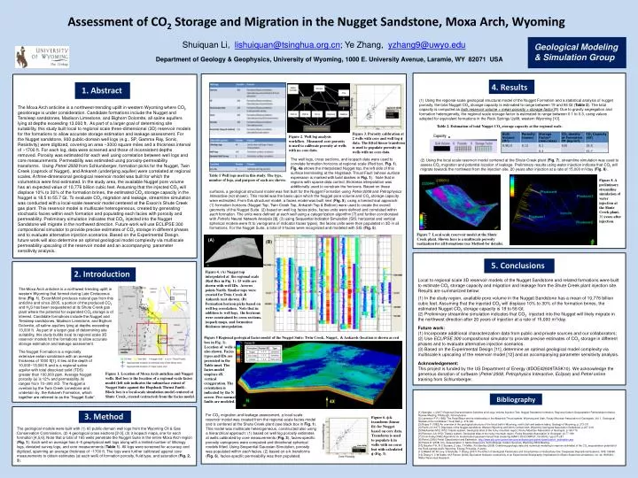
(core data). (B). (core data). Assessment of CO 2 Storage and Migration in the Nugget Sandstone, Moxa Arch, Wyoming. Shuiquan Li, lishuiquan@tsinghua.org.cn ; Ye Zhang, yzhang9@uwyo.edu. Geological Modeling & Simulation Group.

E N D
(core data) (B) (core data) Assessment of CO2 Storage and Migration in the Nugget Sandstone, Moxa Arch, Wyoming Shuiquan Li, lishuiquan@tsinghua.org.cn; Ye Zhang, yzhang9@uwyo.edu Geological Modeling & Simulation Group Department of Geology & Geophysics, University of Wyoming, 1000 E. University Avenue, Laramie, WY 82071 USA employs 4X vertical exaggeration. The orientation is indicated by the N arrow. Two normal and one reverse faults are modeled. 4. Results 1. Abstract (1) Using the regional-scale geological structural model of the Nugget Formation and a statistical analysis of nugget porosity, the total Nugget CO2 storage capacity is estimated to range between 19 and 56 Gt (Table 2). The total capacity is computed as bulk reservoir volume × mean porosity × storage factor [9]. Due to gravity segregation and formation heterogeneity, the regional scale storage factor is estimated to range between 0.1 to 0.3, using values adopted for equivalent formations in the Rock Springs Uplift, western Wyoming [10]. The Moxa Arch anticline is a northwest-trending uplift in western Wyoming where CO2 geostorage is under consideration. Candidate formations include the Nugget and Tensleep sandstones, Madison Limestone, and Bighorn Dolomite, all saline aquifers lying at depths exceeding 13,000 ft. As part of a larger goal of determining site suitability, this study built local to regional scale three-dimensional (3D) reservoir models for the formations to allow accurate storage estimation and leakage assessment. For the Nugget sandstone, 900 public-domain well logs (e.g., SP, Gamma Ray, Sonic, Resistivity) were digitized, covering an area ~3000 square miles and a thickness interval of ~1700 ft. For each log, data were screened and those of inconsistent depths removed. Porosity was estimated for each well using correlation between well logs and core measurements. Permeability was estimated using porosity-permeability transforms. Using Petrel2008 from Schlumberger, formation picks for the Nugget, Twin Creek (caprock of Nugget), and Ankareh (underlying aquifer) were correlated at regional scales. A three-dimensional geological reservoir model was built for which the volumetrics were first estimated. In the study area, the available Nugget pore volume has an expected value of 10,776 billion cubic feet. Assuming that the injected CO2 will displace 10% to 30% of the formation brines, the estimated CO2 storage capacity in the Nugget is 18.5to 55.7 Gt. To evaluate CO2 migration and leakage, streamline simulation was conducted with a local-scale reservoir model centered at the Exxon’s Shute Creek gas plant. This reservoir model is multiscale heterogeneous, created by generating stochastic facies within each formation and populating each facies with porosity and permeability. Preliminary simulation indicates that CO2 injected into the Nugget Sandstone will migrate in the northwest direction. Future work will use ECLIPSE 300 compositional simulator to provide precise estimates of CO2 storage in different phases and to evaluate alternative injection scenarios. Based on the Experimental Design, future work will also determine an optimal geological model complexity via multiscale permeability upscaling of the reservoir model and an accompanying parameter sensitivity analysis. Table 2. Estimation of total Nugget CO2 storage capacity at the regional scale. Figure 3. Porosity calibration at 2 wells with core and well log f data. The fitted linear transform is used to populate porosity in wells with no core data. Figure 2. Well log analysis workflow. Measured core porosity is used to calibrate porosity at wells with no core data. = The well logs, cross sections, and isopach data were used to correlate formation horizons at regional scale (Red box, Fig. 1). Fig. 4a shows the interpolated Nugget top, the left side of this surface terminating at the Hogsback Thrust Fault (whose surface expression is marked with bold dashes in Fig. 1). Note that in regions with sparse data control, thickness interpolation was additionally used to constrain the horizons. Based on these (2) Using the local scale reservoir model centered at the Shute Creek plant (Fig. 7), streamline simulation was used to assess CO2 migration and potential location of leakage. Preliminary results using water injection indicate that CO2 will migrate towards the northwest from the injection site, 20 years after injection at a rate of 15,000 m3/day (Fig. 8). Table 1 Well logs used in this study. The type, number of logs, and purpose of each are shown. Figure 8. A preliminary streamline simulation of water injection at the Shute Creek plant, 20 years after injection. surfaces, a geological structural model was first built for the Nugget Formation using Petrel 2008 and Petrophysics Interactive (not shown). This model was the basis upon which the Nugget pore volume and CO2 storage capacity were estimated. From this structural model, a facies model was built next (Fig. 5), using a hierarchical approach: (1) formation horizons (Nugget Top, Twin Creek Top, Ankareh Top & Bottom) were used to create the overall geometry of the Nugget Suite. (2) based on well log facies picks, facies units were defined and correlated within each formation. The units were defined at each well using a categorization algorithm [7] and further corroborated with Petrel’s Neural Network Analysis [8]. (3) using Sequential Indicator Simulation (SIS; horizontal and vertical spherical models were fit to variograms of indicator facies types), the facies units were then populated in 3D in all formations. For the Nugget Suite, a total of 9 facies were recognized and modeled with SIS (Fig. 5). Figure 7. Local scale reservoir model at the Shute Creek plant. Shown here is a multiscale porosity realization for all formations (see Method for details). (A) 5. Conclusions 2. Introduction Figure 4. (A) Nugget top interpolated at the regional scale (Red Box in Fig. 1). 15 wells are shown with well IDs. Arrows points North. Similar tops were created for Twin Creek & Ankareh (not shown). (B) Formation horizon picks based on well log correlation. Note that in addition to well logs, the horizons were constrained by cross sections, isopach maps, and formation thickness interpolation. • Local to regional scale 3D reservoir models of the Nugget Sandstone and related formations were built to estimate CO2 storage capacity and migration and leakage from the Shute Creek plant injection site. Results are summarized below: • In the study region, available pore volume in the Nugget Sandstone has a mean of 10,776 billion cubic feet. Assuming that the injected CO2 will displace 10% to 30% of the formation brines, the estimated Nugget CO2 storage capacity is 19 to 56 Gt. • Preliminary streamline simulation indicates that CO2 injected into the Nugget will likely migrate in the northwest direction after 20 years of injection at a rate of 15,000 m3/day. • Future work: • Incorporate additional characterization data from public and private sources and our collaborators; • Use ECLIPSE 300 compositional simulator to provide precise estimates of CO2 storage in different phases and to evaluate alternative injection scenarios. • (3) Based on the Experimental Design [11], determine an optimal geological model complexity via multiscale k upscaling of the reservoir model [12] and an accompanying parameter sensitivity analysis. • Acknowledgement: • This project is funded by the US Department of Energy (#DOE42609TASK10). We acknowledge the generous donation of software (Petrel 2008, PetrophysicsInteractive, Eclipse) and Petrel online training from Schlumberger. The Moxa Arch anticline is a northwest-trending uplift in western Wyoming that formed during Late Cretaceous time (Fig. 1). ExxonMobil produces natural gas from this anticline and since 2005, a portion of the produced CO2 and H2S has been sequestered at its Shute Creek gas plant where the potential for expanded CO2 storage is of interest. Candidate formations include the Nugget and Tensleep sandstones, Madison Limestone, and Bighorn Dolomite, all saline aquifers lying at depths exceeding 13,000 ft. As part of a larger goal of determining site suitability, this study builds local to regional scale 3D reservoir models for the formations to allow accurate storage estimation and leakage assessment. Figure 5 Regional geological facies model of the Nugget Suite: Twin Creek, Nugget, & Ankareh (location is shown as red box in Fig. 1). Location of wells is also shown. Facies types and IDs are presented in the Table inset. The facies model employs 4X vertical exaggeration. The orientation is indicated by the N arrow. Five normal faults are modeled. The Nugget Formation is a regionally extensive eolian sandstone with an average thickness of 1000 ft[1]. It lies at the depth of 10,000~13,000 ft and is a regional saline aquifer with total dissolved solid (TDS) greater than 100,000 ppm. Average Nugget porosity (f) is 12% and permeability (k) ranges from 70~300 mD. The Nugget is overlain by the Twin Creek Limestone and underlain by the Ankareh Formation, which together are referred to as the “Nugget Suite”. Figure 1. Location of Moxa Arch anticline and Nugget wells. Red box is the location of a regional-scale facies model (left side indicates the subsurface extent of Nugget Suite against the Hogsback Thrust Fault). Block box is a local-scale simulation model centered at Shute Creek, created (extracted) from the facies model. and within each formation Bibliography 3. Method [1] Spangler, L (2007) Regional Characterization Activities and Large Volume Injection Test, Nugget Sandstone formation, Regional Carbon Sequestration Partnerships Initiative Review Meeting, Pittsburgh, Pennsylvania. [2] Lamerson P R (1982) The Fossil Basin and its relationship to the Absaroka Thrust system, Wyoming and Utah, Rocky Mountain Association of Geologists, Vol. 1, Geological Studies of the Cordilleran Thrust Belt, p. 279-340. [3] Royse F (1982) An overview of the geological structure of the thrust belt in Wyoming, north Utah and eastern Idaho, Geology of Wyoming, p. 273-311. [4] Pacht J A (1977) Digenesis of the Nugget sandstone: Western Wyoming and North Central Utah, Wyoming Geological Association Guidebook, p.207-219. [5] Maclachlan M E(1972) Triassic system, Geological atlas of the rocky mountain region, Rocky Mountain Association of Geologist, p.166-176. [6] Peterson J A(1972) Triassic system, Geological atlas of the rocky mountain region, Rocky Mountain Association of Geologist, p.177-189. [7] Chris Fraley(1998) Algorithms for model-based gaussian hierarchical clustering,SIAM J.SCI.COMPUT.,Vol.20,No.1,pp.270-281 [8] Petrel (2008) Petrel Classification and Estimation, http://www.slb.com/content/services/software/geo/petrel/classification_estimation.asp [9] Peters D (2008) CO2 Sequestration in Saline Reservoirs, Schlumberger Carbon Services, Wyoming DEQ Meeting. [10] Stauffer P H, R C Surdam, Z Jiao, T A Miller, R d Bentley (2008) Combining geologic data and numerical modeling to improve estimates of the CO2 sequestration potential of the Rock springs Uplift, Wyoming, Energy Procedia, in press. [11] Millekin W, M Levy, S Strebelle, Y Zhang (2007) The Effect of Geological Parameters and Uncertainties on Subsurface flow: Deepwater Depositional Systems, SPE 109950. [12] Zhang Y, C W Gable, M A Person (2006) Equivalent hydraulic conductivity of an Experimental Stratigraphy: Implications for Basin-Scale flow simulations, vol. 42, W05404, Water Resources Research. For CO2 migration and leakage assessment, a local-scale reservoir model was created from the regional-scale facies model and is centered at the Shute Creek plant (see black box in Fig. 1). This model was multiscale heterogeneous, constructed also using a hierarchical approach: (1) based on well log porosity estimates at wells calibrated by core measurements (Fig. 3), facies-specific porosity variograms were computed and directional spherical models fitted. Using Sequential Gaussian Simulation, porosity was populated within each facies. (2) based on f-k transforms (Fig. 6), facies-specific permeability was then populated. Figure 6. f-k transform (linear fit) for Nugget based on core data. Transform is used to populate k in wells with no cores but with calculated f (Fig. 3). The geological models were built with (1) 60 public-domain well logs from the Wyoming Oil & Gas Conservation Commission, (2) 4 geological cross sections [2-3], (3) 3 isopach maps, one for each formation [4,5,6]. Note that a total of 165 wells penetrate the Nugget Suite in the entire Moxa Arch region (Fig. 1). Each well on average has 4~5 geophysical well logs along with a limited number of lithology logs, deviated survey logs, and core measurements (Table 1). All logs were screened for accuracy and digitized, spanning an average thickness of ~1700 ft. The logs were further calibrated against core measurements to obtain estimates (at each well) of formation porosity, fluid type, and saturation (Fig. 2, 3).