Download
1 / 14
150 likes | 665 Views
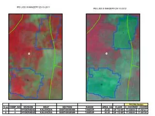
Republic of Zambia Ministry of Health. Indoor Residual Spraying (IRS) GIS Training and Spray Area Mapping Basics of Global Positioning Systems (GPS). Training Workshop: 29 February –3 March 2008, Chipata, Zambia Web: www.nmcc.org.zm Email: malaria@nmcc.org.zm. Definition of a GPS.

E N D
Republic of Zambia Ministry of Health Indoor Residual Spraying (IRS) GIS Training and Spray Area MappingBasics of Global Positioning Systems (GPS) Training Workshop: 29 February–3 March 2008, Chipata, Zambia Web: www.nmcc.org.zm Email: malaria@nmcc.org.zm
Definition of a GPS A set of satellites in geostationary orbits used to determine geographical location anywhere on the earth by means of portable electronic devices.
Trilateration: How GPS Determines a Location GPS is based on satellite ranging: • Calculating the distances between the receiver and the position of 3 or more satellites (4 or more if elevation is desired) and then applying some mathematics. • Assuming the positions of the satellites are known, the location of the receiver can be calculated by determining the distance from each of the satellites to the receiver.
How GPS Determines a Location cont. • GPS takes these 3 or more known references and measured distances and “triangulates” an additional position. Based on this principle, one needs to know the following information in order to compute one’s position: • What is the precise location of 3 or more known points (GPS satellites)? • What is the distance between the known points and the position of the GPS receiver?
Determining Current Locations of GPS Satellites • GPS satellites are orbiting the earth at an altitude of about 11,000 miles. • Paths of the satellites vs. time can be predicted with great accuracy. • Orbits, and thus the locations of the satellites, are known in advance.
Determining Current Locations of GPS Satellites, cont. • GPS receivers store orbit information for all of the GPS satellites in what is known as an almanac. • Radio waves travel at the speed of light (about 186,000 miles per second). • If the exact time of signal transmission and exact time it was received are known, the signal travel time can be determined.
3-Dimensional Location • Four satellites are needed to give a 3-dimensional position. • Three measurements can be used to locate a point. • Unfortunately, it is impossible to synchronize these 2 clocks. • A fourth variable, time, must be determined in order to calculate a precise location.
Causes of GPS Errors • Atmospheric conditions • Ephemeris errors • Clock drift • Measurement noise
Selective Availability • The US Department of Defense has the ability to degrade the Course Acquisition Code at any time. • This will cause civilian receivers to miscalculate positions by up to 100 meters. • Differential correction will adjust position to submeter accuracy.
Measuring GPS Accuracy • Dilution of precision (DOP) is an indicator of the quality of the geometry of the satellite constellation.
Using Differential GPS to Increase Accuracy • Differential correction requires a second GPS receiver, a base station, collecting data at a stationary position on a precisely known point (typically it is a surveyed benchmark).
GPS and Canopy • GPS receivers require a line of sight to the satellites in order to obtain a signal representative of the true distance from the satellite to the receiver.
Advantages of GPS Navigation • GPS takes navigation to a higher level by providing accurate position and course information. • Has implications for health, agriculture, environment, navigation, defense, etc.