html5-img
1 / 2

Radar Image of Pacific Coast of Guatemala March 10, 2000

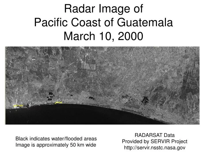
Radar Image of Pacific Coast of Guatemala March 10, 2000. RADARSAT Data Provided by SERVIR Project http://servir.nsstc.nasa.gov. Black indicates water/flooded areas Image is approximately 50 km wide. Radar Image of Pacific Coast of Guatemala October 10, 2005. Flooded Areas. RADARSAT Data

Michelle
Download Presentation

Radar Image of Pacific Coast of Guatemala March 10, 2000

An Image/Link below is provided (as is) to download presentation Download Policy: Content on the Website is provided to you AS IS for your information and personal use and may not be sold / licensed / shared on other websites without getting consent from its author. Content is provided to you AS IS for your information and personal use only. Download presentation by click this link. While downloading, if for some reason you are not able to download a presentation, the publisher may have deleted the file from their server. During download, if you can't get a presentation, the file might be deleted by the publisher.

E N D

Presentation Transcript


  1. Radar Image ofPacific Coast of GuatemalaMarch 10, 2000 RADARSAT Data Provided by SERVIR Project http://servir.nsstc.nasa.gov Black indicates water/flooded areas Image is approximately 50 km wide

  2. Radar Image ofPacific Coast of GuatemalaOctober 10, 2005 Flooded Areas RADARSAT Data Provided by SERVIR Project http://servir.nsstc.nasa.gov Black indicates water/flooded areas Image is approximately 50 km wide

More Related