Download
1 / 1
10 likes | 119 Views
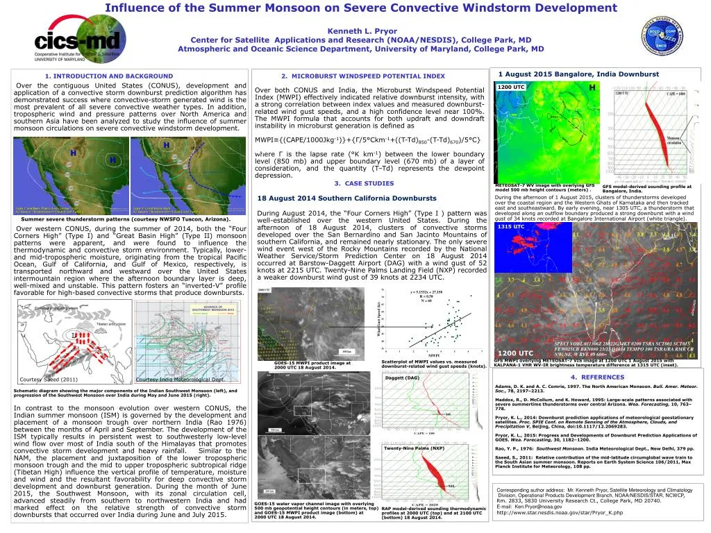
Over the contiguous United States (CONUS), development and application of a convective storm downburst prediction algorithm has demonstrated success where convective-storm generated wind is the most prevalent of all severe convective weather types. In addition, tropospheric wind and pressure patterns over North America and southern Asia have been analyzed to study the influence of summer monsoon circulations on severe convective windstorm development. This presentation offers preliminary results of the study of summer monsoon patterns associated with thunderstorm downburst generation and severity, and discusses the performance of a downburst prediction algorithm that is dependent on the temperature and moisture stratification of the lower troposphere. Over western CONUS, during the summer of 2014, both the “Four Corners High” (Type I) and “Great Basin High” (Type II) monsoon patterns were apparent, and were found to influence the thermodynamic and convective storm environment. During the month of June 2015, the Southwest Monsoon, with its zonal circulation cell, advanced steadily from southern to northwestern India and had marked effect on the relative strength of convective storm downbursts that occurred over India during June and July 2015. Over both regions, the Microburst Windspeed Potential Index (MWPI) effectively indicated relative downburst intensity, with a strong correlation between index values and measured downburst-related wind gust speeds, and a high confidence level near 100%. This was especially apparent over India, where the MWPI effectively indicated downburst intensity in both pre-monsoon and monsoon environments. Over western CONUS, the summer monsoon pattern fosters an “inverted V” thermodynamic profile characterized by a mid-tropospheric moist layer overlying a deep convective boundary layer, while over the Indian Peninsula, the onset of the summer monsoon results in the development of a deep lower tropospheric moist layer with an overlying mid-tropospheric dry layer, a pattern typically associated with wet downbursts over southeastern CONUS.

E N D
Influence of the Summer Monsoon on Severe Convective Windstorm Development Kenneth L. Pryor Center for Satellite Applications and Research (NOAA/NESDIS), College Park, MD Atmospheric and Oceanic Science Department, University of Maryland, College Park, MD JP181 1 August 2015 Bangalore, India Downburst INTRODUCTION AND BACKGROUND 2. MICROBURST WINDSPEED POTENTIAL INDEX Over both CONUS and India, the Microburst Windspeed Potential Index (MWPI) effectively indicated relative downburst intensity, with a strong correlation between index values and measured downburst-related wind gust speeds, and a high confidence level near 100%. The MWPI formula that accounts for both updraft and downdraft instability in microburst generation is defined as MWPI≡{(CAPE/1000Jkg-1)}+{Г/5°Ckm-1+((T-Td)850-(T-Td)670)/5°C} where Г is the lapse rate (°K km-1) between the lower boundary level (850 mb) and upper boundary level (670 mb) of a layer of consideration, and the quantity (T–Td) represents the dewpoint depression. . Over the contiguous United States (CONUS), development and application of a convective storm downburst prediction algorithm has demonstrated success where convective-storm generated wind is the most prevalent of all severe convective weather types. In addition, tropospheric wind and pressure patterns over North America and southern Asia have been analyzed to study the influence of summer monsoon circulations on severe convective windstorm development. H 1200 UTC a) 3. CASE STUDIES 18 August 2014 Southern California Downbursts During August 2014, the “Four Corners High” (Type I ) pattern was well-established over the western United States. During the afternoon of 18 August 2014, clusters of convective storms developed over the San Bernardino and San Jacinto Mountains of southern California, and remained nearly stationary. The only severe wind event west of the Rocky Mountains recorded by the National Weather Service/Storm Prediction Center on 18 August 2014 occurred at Barstow-Daggett Airport (DAG) with a wind gust of 52 knots at 2215 UTC. Twenty-Nine Palms Landing Field (NXP) recorded a weaker downburst wind gust of 39 knots at 2234 UTC. METEOSAT-7 WV image with overlying GFS model 500 mbheight contours (meters) . GFS model-derived sounding profile at Bangalore, India. During the afternoon of 1 August 2015, clusters of thunderstorms developed over the coastal region and the Western Ghats of Karnataka and then tracked east and southeastward. By early evening, near 1305UTC, a thunderstorm that developed along an outflow boundary produced a strong downburst with a wind gust of 34 knots recorded at Bangalore International Airport (white triangle). Summer severe thunderstorm patterns (courtesy NWSFO Tuscon, Arizona). 1315 UTC * Text Over western CONUS, during the summer of 2014, both the “Four Corners High” (Type I) and “Great Basin High” (Type II) monsoon patterns were apparent, and were found to influence the thermodynamic and convective storm environment. Typically, lower- and mid-tropospheric moisture, originating from the tropical Pacific Ocean, Gulf of California, and Gulf of Mexico, respectively, is transported northward and westward over the United States intermountain region where the afternoon boundary layer is deep, well-mixed and unstable. This pattern fosters an “inverted-V” profile favorable for high-based convective storms that produce downbursts. Schematic diagram showing the major components of the Indian Southwest Monsoon (left), and progression of the Southwest Monsoon over India during May and June 2015 (right). In contrast to the monsoon evolution over western CONUS, the Indian summer monsoon (ISM) is governed by the development and placement of a monsoon trough over northern India (Rao 1976) between the months of April and September. The development of the ISM typically results in persistent west to southwesterly low-level wind flow over most of India south of the Himalayas that promotes convective storm development and heavy rainfall. Similar to the NAM, the placement and juxtaposition of the lower tropospheric monsoon trough and the mid to upper tropospheric subtropical ridge (Tibetan High) influence the vertical profile of temperature, moisture and wind and the resultant favorability for deep convective storm development and downburst generation. During the month of June 2015, the Southwest Monsoon, with its zonal circulation cell, advanced steadily from southern to northwestern India and had marked effect on the relative strength of convective storm downbursts that occurred over India during June and July 2015. SPECI VOBL 011306Z 28022G34KT 0200 TSRA SCT001 SCT015 FEW025CB BKN080 23/23 Q1014 TEMPO 100 TSRA/RA RMK CB NW. NE, W RVE 09 600= 1200 UTC b) GFS MWPI overlying METEOSAT-7 VIS image at 1200 UTC 1 August 2015 with KALPANA-1 VHR WV-IR brightness temperature difference at 1315 UTC (inset). Scatterplot of MWPI values vs. measured downburst-related wind gust speeds (knots). GOES-15 MWPI product image at 2000 UTC 18 August 2014. 4. REFERENCES Daggett (DAG) Courtesy Saeed (2011) Courtesy India Meteorological Dept. Adams, D. K. and A. C. Comrie, 1997. The North American Monsoon. Bull. Amer. Meteor. Soc., 78, 2197–2213. Maddox, R., D. McCollum, and K. Howard, 1995: Large-scale patterns associated with severe summertime thunderstorms over central Arizona. Wea. Forecasting, 10, 763–778. Pryor, K. L., 2014: Downburst prediction applications of meteorological geostationary satellites. Proc. SPIE Conf. on Remote Sensing of the Atmosphere, Clouds, and Precipitation V, Beijing, China, doi:10.1117/12.2069283. Pryor, K. L., 2015: Progress and Developments of Downburst Prediction Applications of GOES. Wea. Forecasting, 30, 1182–1200. Rao, Y. P., 1976: Southwest Monsoon. India Meteorological Dept., New Delhi, 379 pp. Saeed, S., 2011: Relative contribution of the mid-latitude circumglobalwave train to the South Asian summer monsoon. Reports on Earth System Science 106/2011, Max Planck Institute for Meteorology, 108 pp. Twenty-Nine Palms (NXP) Corresponding author address: Mr. Kenneth Pryor, Satellite Meteorology and Climatology Division, Operational Products Development Branch, NOAA/NESDIS/STAR, NCWCP, Rm. 2833, 5830 University Research Ct., College Park, MD 20740. E-mail: Ken.Pryor@noaa.gov http://www.star.nesdis.noaa.gov/star/Pryor_K.php GOES-15 water vapor channel image with overlying 500 mbgeopotential height contours (in meters, top) and GOES-15 MWPI product image (bottom) at 2000 UTC 18 August 2014. RAP model-derived sounding thermodynamic profiles at 2000 UTC (top) and at 2100 UTC (bottom) 18 August 2014.