Download

1 / 29
320 likes | 942 Views
Sarsat Search and Rescue Satellite Aided Tracking. Cospas-Sarsat provides, free-of-charge, ... A second satellite pass is needed to determine which is the correct one ...

E N D
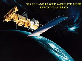
Slide 1:SARSAT
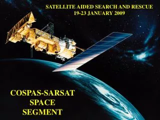
COSPAS-SARSAT Cospas COsmicheskaya Systyema Poiska Aariynyich Sudov which translates loosely into �Space System for the Search of Vessels in Distress� Sarsat Search and Rescue Satellite Aided Tracking Cospas-Sarsat provides, free-of-charge, distress alert and location information to search and rescue authorities anywhere in the world for maritime, aviation and land users in distress. SARSAT System Operation Local User Terminal Mission Control Center Rescue Coordination Center LEO Satellites GEO Satellites Emergency Beacons LEO and GEO Satellites Two types of satellites: Low-earth orbiting (LEO)/polar orbiting (LEOSAR); and Geosynchronous earth orbiting (GEO or GEOSAR) � 406 MHz only Local User Terminals 39 LEOLUT Sites Local User Terminals 6 GEOLUTsSlide 7:LEO and GEO SAR Satellites
Geosynchronous Earth Orbiting (406 MHz only) Large �footprint� � sees almost � of the Earth Holds position over the equator at a fixed longitude At about 23,000 miles altitude, its orbital speed exactly matches the speed of the Earth�s rotation Low Earth Orbiting (121.5 MHz and 406 MHz) Smaller �footprint�� sees smaller area Lower than GEO � at about 530 miles altitude Moves over surface of Earth Orbital period about 100 minutes Orbit traces a sine-wave over a map Moves in a circle roughly crossing the North and South poles The Earth rotates underneath, so it covers a different area on each orbit
Slide 8:SARSAT: A Snapshot in Time
SARSAT: A 3D Look LEO and GEO Satellites Typical Satellite Footprints GEO Footprint LEO Footprint Doppler Position From LEO Satellites 121.5 MHz Local Coverage � 406 MHz Global Coverage 121.5/243 MHz Beacon LUT Detection of a 121.5/243 MHz beacon requires mutual visibility between beacon, satellite and ground station (LUT) 406 MHz Beacon Satellite LUT 406 MHz beacon detections can be stored on board the satellite and re-broadcast later Satellite
Slide 12:Doppler Shift Position Solution
As a LEO satellite passes abeam the signal, the received radio frequency shifts Analogous to sound frequency shift of passing train or car Sharpness of frequency shift can be used to determine distance away from satellite�s ground track
Slide 13:Doppler Shift Position Solution
Slide 14:Doppler Shift Position Solution
Doppler shift on 121.5 MHz provides two candidate positions A second satellite pass is needed to determine which is the correct one Satellite location at Doppler zero shift
Slide 15:Doppler Shift Position Solution
Doppler shift on 121.5 MHz provides two candidate positions A second satellite pass is needed to determine which is the correct one 2nd Satellite location at Doppler zero shift Position that agrees with 1st satellite � this is called a �merge�
Slide 16:Understanding �merges�
Each successive merge is cumulative (i.e. all elementals that appear to be the same target are averaged together)
Slide 17:Doppler Shift Position Solution
On 406 MHz, the stronger, higher quality signal permits using the Doppler shift component of the Earth�s rotation to determine which side of the satellite the signal is on Thus, 95% of the time, only one satellite pass is needed
Slide 18:Variations and Capabilities
121.5 MHz � Usual for ELTs and EPIRBs Low power, continuous analog broadcast Must be �heard� by satellite for at least 4 minutes to generate a location solution SARSAT Location is within 11NM (90% accuracy) 48 Hour nominal battery life 243 MHz � Used by Military Characteristics similar to 121.5 ELTs Received only by US satellites Increases time between passes
Slide 19:Variations and Capabilities
406 MHz � New ELT frequency Digital data burst with UIC � Unique Identification Code Satellite must �hear� 3 bursts (about 3 minutes) to generate a location solution Most include a 121.5 transmitter to allow searchers to hear and locate the signal Data burst information is stored on board satellites until it can be downloaded to a LUT; provides global coverage Geosyncronous satellites also monitor for instantaneous alert Optional GPS data 5 Watts power
Slide 20:Variations and Capabilities
406 MHz � New ELT frequency (cont.) Unique Identification Code Requires owner registration Database associates UIC with vessel or aircraft and its owner Allows most false alarms to be resolved with a phone call Eliminates non-beacon false alarms Stronger, higher quality signal for satellite reception and position determination
Problems with 121.5 MHz Alerting Number of False Alerts Timeliness Accuracy Identification Reliability/Operation Problems with 121.5 MHz Alerting Number of False Alerts Approximately 120,000 alerts sent to United States RCCs annually 75% of the alerts originate from non-beacon sources Only a few hundred real distress alerts annually False alert rate (for all alerts, beacon and non-beacon, sent to RCCs) over 99% Problems with 121.5 MHz Alerting Timeliness Due to the number of false alerts and the inability to resolve ambiguity on the first pass, RCCs usually have to wait for the second or third satellite pass before responding. This delays search and rescue efforts by up to two hours or more The response can be further delayed because the 121.5 MHz system requires mutual visibility Problems with 121.5 MHz Alerting Accuracy Generally between 7 - 12 miles. Corresponding search area approximately 450 square miles Identification Lack of beacon identification means that resources have to be expended in order to determine the source - real alert, false alert or interferer Problems with 121.5 MHz Alerting Reliability/Operation Lower power transmitters (50 - 100 mw) are not designed to be detected by satellite Interference in 121.5 MHz band can prevent signals from being detected by satellite A Typical Day at AFRCC End of 121.5 MHz Satellite Processing The termination of 121.5 MHz satellite alerting refers to the cessation of satellite processing of 121.5 MHz signals It does not mean the elimination of the use of the frequency or the use of 121.5 MHz emergency beacons 406 MHz EPIRBs and ELTs will continue to have a low power 121.5 MHz transmitter for homing purposes 243 MHz satellite processing will also be terminatedSlide 28:Variations and Capabilities Recap: 121.5/243 MHz vs. 406 MHz
Slide 29:SARSAT For More Information�
http://www.sarsat.noaa.gov/ http://www.cospas-sarsat.org/ http://www.uscg.mil/hq/g-o/g-opr/sar.htm http://www.acc.af.mil/afrcc/ http://poes.gsfc.nasa.gov/sar/sar.htm