Download
1 / 17
170 likes | 627 Views
Microphysical Considerations in Remote Sensing of Precipitation Daniel Rosenfeld, Hebrew University of Jerusalem, Israel and Vincenzo Levizzani, ISAC-CNR, Bologna, Italy New geostationary multispectral capabilities allow us to retrieve cloud microstructure and precipitation forming processes

E N D
Microphysical Considerations in Remote Sensing of Precipitation Daniel Rosenfeld, Hebrew University of Jerusalem, Israel and Vincenzo Levizzani, ISAC-CNR, Bologna, Italy
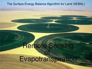
New geostationary multispectral capabilities allow us to retrieve cloud microstructure and precipitation forming processes 0.8 mm 3.9r mm 10.8 mm Namibia, MSG 2003 09 07 11:57 2_4r_9
The classification scheme of convective clouds into microphysical zones according to the shape of the temperature – effective radius relations Note that in extremely continental clouds re at cloud base is very small, the coalescence zone vanishes, mixed phase zone starts at T<-15oC, and the glaciation can occur at the most extreme situation at the height of homogeneous freezing temperature of –39oC. In contrast, maritime clouds start with large re at their base, crossing the precipitation threshold of 14 mm short distance above the base. The deep rainout zone is indicative of fully developed warm rain processes in the maritime clouds. The large droplets freeze at relatively high temperatures, resulting in a shallow mixed phase zone and a glaciation temperature reached near –10oC Rosenfeld and Lensky, 1998
Very maritime with warm rain More vigorous and less maritime Extremely continental MSG 2004 08 26 15:12 2_4r_9
Disdrometer measured DSD of continental and maritime rainfall, as microphysically classified by VIRS overpass. The DSD is averaged for the rainfall during +- 18 hours of the overpass time. The disdrometers are in Florida (Teflun B),Amazon (LBA),India (Madras) and Kwajalein. Application of TRMM Z-R shows a near unity bias in maritime clouds, but overestimates by a factor of 2 rainfall from continental clouds. Rosenfeld and Woodley, Meteorological Monographs, 2003
Processes determining the Rain Drop Size Distribution Equilibrium DSD: Z = 600 R; D0e = 1.75 mm Hu and Srivastava (1995)
Impact of Cloud DSD on the evolution of Rain DSD • Maritime Cloud DSD • Cloud drop coalescenceDrizzle • Drizzle coalescence Raindrops • More coalescence larger raindrops • breakup and equilibrium DSD • Approaching D0e from below • Continental Cloud DSD • Cloud drop accretiongraupel • haillarge raindrops • breakup • equilibrium DSD • Approaching D0e from above
Equilibrium Maritime Continental Trends of D0 for convective maritime and continental clouds. Rain water content, W [g m-3] as a function of rain drop median mass diameter D0 [cm] and drop concentration NT [m-3] for R=30 mm h-1, For all Z-R’s.
Summary: All Z-R classifications combined The variation of drop median mass diameterD0 with the liquid water content (W) and total drop concentration (NT) for R=10 and 30 mm hr-1 of convective rainfall in maritime and continental regimes.
Differences in rain DSD forming processes between Maritime and Continental Clouds: In Maritime clouds there are: More Coalescence Rainout D0 < D0e Larger R(Z) Lower updrafts Smaller D0 Larger R(Z) Less evaporation Smaller D0 Larger R(Z) In Continental clouds there are: Less Coalescence No Drizzle No small rain drops Hydrometeors start as graupel and hail D0 > D0e Smaller R(Z) Larger updrafts Larger D0 Smaller R(Z) More evaporation Larger D0 Smaller R(Z) .
Z-R relations for rainfall from maritime and continental convective clouds. The rain intensities for 40 and 50 dBZ are plotted in the figure. Note the systematic increase of R for a given Z for the transition from continental to maritime clouds. 1. Swiss Locarno thunderstorms, continental (Joss and Waldvogel , 1970) 830 1.50 2. Arizona mountain thunderstorms (Foote 1966) 646 1.46 3. North Dakota, September. 429 1.59 4. Illinois thunderstorms, continental (Sims, 1964) 446 1.43 5. Oklahoma thunderstorms, moderate continental (Petrocchi and Banis, 1980) 316 1.36 6. Congo Squall line. Tropical continental (Sauvageot, 1994) 425 1.29 7. PurtoRico thunderstorms. Coastal, moderate maritime (Ulbrich et al., 1999). 261 1.43 8. Darwin Squalls. Coastal, tropical maritime (Maki et al., 2001) 232 1.38 9. Darwin Convective DSD. Coastal, tropical maritime (Tokay et al., 1995) 175 1.37 10. COARE Convective DSD. Equatorial maritime (Tokay and Short, 1996). 139 1.43 11. Marshall Trade wind cumulus. Warm rain maritime (Stout and Mueller, 1968) 126 1.47 12. Marshall Showers. Equatorial maritime. (Stout and Mueller, 1968) 146 1.42 E. Equilibrium DSD. 600 1.00
Highly Continental SAHEL MSG 2003 05 20 13:42 2_4r_9 Moderate Equatorial
S. Nesbitt and E. Zipser MODIS Aerosol Optical Thickness, 2001 ITCZ clouds cleaner Larger cloud drops Smaller raindrops and less and smaller ice aloft less PR and TMI over-estimate
S. Nesbitt and E. Zipser MODIS Aerosol Optical Thickness, 2001 ITCZ clouds cleaner Larger cloud drops Smaller raindrops and less and smaller ice aloft less PR and TMI over-estimate
S. Nesbitt and E. Zipser MODIS Aerosol Optical Thickness, 2001 ITCZ clouds cleaner Larger cloud drops Smaller raindrops and less and smaller ice aloft less PR and TMI over-estimate
S. Nesbitt and E. Zipser MODIS Aerosol Optical Thickness, 2001 ITCZ clouds cleaner Larger cloud drops Smaller raindrops and less and smaller ice aloft less PR and TMI over-estimate
Summary A review of Z-R relations based on cloud physics RDSD forming processes revealed that Z-R behave systematically, producing larger R for the same Z when going from: Continental Maritime (X3) Maritime Orographic (X4) Stratiform Convective Maritime (X2) Opportunities Classification criteria can be detected by: Satellite (cloud drop effective radius for continentality); Radar 3-D structure; Dynamics of orographic lifting. Potential for dynamic Z-R for space and ground based radars, accounting for systematic biases by factors of 2 to 4. Potential for guiding selection of PMW libraries …RAINCLOUDS