Download
1 / 7
0 likes | 4 Views
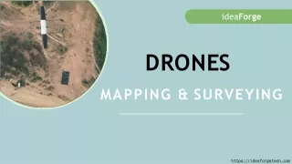
Oman, a land steeped in history and diverse landscapes, is experiencing a surge in the use of mapping drones. These versatile aerial robots are revolutionizing various sectors, from archaeology and conservation to infrastructure development and agriculture.

E N D
Unveiling the Jewel of Arabia: Why Mapping Drones Are Soaring in Oman
Oman, a land steeped in history and diverse landscapes, is experiencing a surge in the use of mapping drones. These versatile aerial robots are revolutionizing various sectors, from archaeology and conservation to infrastructure development and agriculture. But why exactly are mapping drones gaining such popularity in this unique Arabian nation? Customized Drones™– Unveiling the Jewel of Arabia: Why Mapping Drones Are Soaring in Oman
From Humble Beginnings to Industrial Advancements: Drones initially took flight with security and safety in mind. However, their evolution led them into the industrial and commercial spheres, expanding their reach far beyond surveillance. In 2013, the marriage of drone technology with photogrammetry, where data is processed for design and assessment, opened a new era in aerial photography. Since then, continuous advancements have refined image quality and expanded capabilities. Customized Drones™– Unveiling the Jewel of Arabia: Why Mapping Drones Are Soaring in Oman
Why Oman Embraces Mapping Drones: Accuracy Beyond Human Limits: Compared to traditional surveying methods prone to human error, drones collect data with precise measurements and fine details, even in challenging terrain. This meticulous approach provides reliable data for informed decision-making. Efficiency on Wings: Gone are the days of time-consuming ground surveys. Drones map vast areas quickly, saving valuable time and resources. Imagine capturing the intricate details of ancient archaeological sites or sprawling infrastructure projects in a fraction of the time compared to traditional methods. Customized Drones™– Unveiling the Jewel of Arabia: Why Mapping Drones Are Soaring in Oman
Safety First, Always: Drones eliminate the need for human exposure to hazardous or difficult-to- reach areas like steep cliffs, dense forests, or active construction zones. This reduces the risk of accidents while ensuring data collection in previously inaccessible locations. Cost-Effective Exploration: Compared to conventional aerial surveys involving manned aircraft or satellite imagery, drones offer a budget-friendly alternative. Their ability to deliver high-resolution imagery and topographic information at a fraction of the price makes them accessible to diverse industries, from agriculture and urban planning to infrastructure development and environmental monitoring. Versatility Unbound: The applications of mapping drones extend far beyond land surveys. They play crucial roles in environmental monitoring, disaster management, mining exploration, crop health assessment, and precision farming techniques. This versatility allows businesses to maximize their potential across various sectors, improving operational outcomes while reducing costs. Customized Drones™– Unveiling the Jewel of Arabia: Why Mapping Drones Are Soaring in Oman
Oman's Untapped Potential Customized Drones™ is committed to supporting Oman's journey of discovery and development. We offer customized solutions for diverse aerial mapping needs, collaborating on research and development projects to push the boundaries of drone technology. By leveraging our expertise, we aim to unlock the immense potential that mapping drones hold for Oman's future, from preserving its rich cultural heritage to shaping its sustainable development. Join us in exploring the possibilities. Contact us at info@c-drones.com to learn more. Customized Drones™– Unveiling the Jewel of Arabia: Why Mapping Drones Are Soaring in Oman
Contact Customized Drones™ for more information Location: Maktoum Road, Golden Business Centre, Offices 203-204 – Dubai UAE Email: info@c-drones.com Website: https://c-drones.com/aerial-surveying-and-mapping-drones/ Contact : +971 4 295 8013