Download
1 / 20
260 likes | 1.01k Views
Geological Modeling: Introduction. Dr. Irina Overeem Community Surface Dynamics Modeling System University of Colorado at Boulder September 2008 . Course Objective.

E N D
Geological Modeling:Introduction Dr. Irina Overeem Community Surface Dynamics Modeling System University of Colorado at Boulder September 2008
Course Objective Geoscientists find resources by assessing the characteristics and constraints of the earth subsurface. The subsurface has been formed over millions of years, and by the interaction of a host of sedimentary processes and time-varying boundary conditions like climate, sea level and tectonics. This course aims at exploring Geological Modeling techniques as: • Learning tools to disentangle complex interactions of sedimentary systems and time-varying boundary conditions. • Quantitative tools to create 3D geological models of the subsurface, including properties like grain size, porosity and permeability. • A means to quantify uncertainties in the subsurface models.
Course outline 1 • Lectures by Irina Overeem: • Introduction and overview • Deterministic and geometric models • Sedimentary process models I • Sedimentary process models II • Uncertainty in modeling • Lecture by Overeem & Teyukhina: • Synthetic migrated data
Geological Modeling Primary objective of geological characterization is concerned with predicting the spatial variation of geological variables. Variable Any property of the geological subsurface that exhibits spatial variability and can be measured in terms of real numerical values. Spatial Variation Typically the subsurface is anisotropic, spatially complex and sedimentary bodies are internally heterogeneous.
Geological Modeling > Reservoir Architecture Modeling • Construction (e.g. Westerscheldt tunnel) • Groundwater flow models for drinkwater and irrigation • Mapping of ore deposits, or gravel & sand mining • Mapping for mine burial, naval warfare…
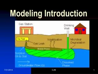
pebbly sand silty sand coarse sand Contaminant transport at Gardermoen Airport, NO Hydraulic conductivities vary within topset, foreset, and bottomset sedimentary layers. KTFS = 6.3 * 10 -4 , KFFS = 3.2 * 10 -6 m/s Groundwater flow in the coarse sandy units can be extremely rapid (> 500 m/day). Assess risk for contaminant transport need a subsurface flow model
Seafloor variability, New Jersey Margin, USA New Jersey shallow shelf. Assess variability in seafloor properties for sonar signal propagation (US Navy). Geostatistics of seabed heterogeneity plotted using semivariograms. (Data courtesy: Chris Jenkins, CSDMS)
Well data correlation in the shallow subsurface of the Tambaredjo Field, Surinam • Tambaredjo Reservoir in fluvial deposits, Staatsolie Suriname NV • Assess connectivity of sandbodies to optimize recovery • Data Courtesy: Applied Earth Sciences, Delft University of Technology
Introduction • Modern reservoir characterisation started around 1980: • Reason: deficiency of oil recovery techniques (inadequate reservoir description) • Aim: predict inter-well distributions of relevant properties (φ, K) • Subsurface (inter-well) heterogeneity cannot be measured: • Seismic data (large support, low resolution) • Well data (small support, high resolution) • Complementary sources of information: • Geological models • Statistical models • Combine data and models ‘static’ reservoir model
Some thoughts on Support and resolution… • Seismic data (large support, low resolution) • What are typical sizes of a 3D seismic dataset? • What is typical resolution of 3D seismic data? • Well data (small support, high resolution) • What is the typical size of a well? Spacing? • What fraction of the subsurface is sampled? • What is typical resolution of well data?
Static reservoir models • Reservoir geology is the science (art?) of building predictive reservoir models on the basis of geological knowledge (= data, interpretations, models) • A reservoir model depicts spatial variation of lithology (porosity and permeability): “static” model • Simulations of multi-phase flow (“dynamic” models) require high-quality “static” reservoir models • Static reservoir models are improved through analysis of dynamic data: iterative process
Geological Modeling: different tracks Reservoir Data Seismic, borehole and wirelogs Data-driven modeling Process modeling Stochastic Model Sedimentary Process Model Deterministic Model Static Reservoir Model Upscaling Flow Model
Elements of the geological model: Bounding surfaces Distributions of physical properties between surfaces Faults OWC, GWC, GOC Conditioned to well data ? Geological model
Concepts: Deterministic Models • Deterministic models involve data collection and information processing to infer correlations and develop understanding of stratal geometry. • The deterministic model inferred fully acknowledges the data; the model contains no random components; consequently, each component and input is determined exactly. Computer visualization of known faults Example from RML-Geosim
Concepts: Stochastical Models • Statistics: science of exploring, analyzing and summarizing data • Statistical model: deterministic summary of the data with quantified uncertainty. • Stochastic = Deterministic + Random • Noise is random by definition, most data are stochastic • Apparent randomness implies sensitivity to initial conditions • Stochastic simulation: generation of hypothetical data (realizations) from a statistical model by feeding it (pseudo)random input values. • MOST COMMONLY USED IN PETROLEUM INDUSTRY • Examples: PETREL (Shell), RML-Geosim (IFP), these techniques will be used in Production Geology Course!
Concepts: Sedimentary Process Models • Sedimentary Process Models consist of causative factors (input) that undergo dynamical physical processes and result in an prediction of stratigraphy (output). prograding topsets sandy turbidites river plume muds Simulation of 12,000 yrs of glacio-fluvial sedimentation in Arctic setting- sea level variation –40m, +5m, +15m- seasonal time-steps, Holocene climate
Why is geological modeling difficult? • The output of many natural systems exhibits apparent randomness, which is usually caused by extreme sensitivity to initial conditions. Initial conditions and physical laws of such systems cannot be inferred from the output. • Measurements are a finite sample of the output (all possible realisations of the system). • Statistical models may be used to describe such measurements in the absence of a physical model. • Geological modeling software (a worst-case scenario): • Designed by statisticians who know little about geology • Applied by geologists / engineers who know little about statistics • Many things can and will go wrong !
Upscaling issues • In addition to the natural scales of heterogeneity in the system and the scale of the measurements, there is also the scale of the discrete elements (grid blocks) in a reservoir model. • Upscaling measurements to grid-block scale is a critical issue in geological modeling and the object of active research • Common errors in numerical reservoir models: • Discretisation errors • Upscaling errors • Input errors • Geological modeling aims at minimizing the input errors to improve reservoir-model performance
Useful references on statistical analysis of geological data • Jensen, J.L., Lake, L.W., Corbett, P.W.M., Goggin, D.J., 2000. Statistics for petroleum engineers and geoscientists – 2nd Edition. Elsevier, Amsterdam, 338 p. (devoted to geostatistical modelling, fairly advanced level, poor graphics, quite expensive) • Davis, J.C., 2002. Statistics and data analysis in geology - 3rd Edition. Wiley, New York, 638 p. (comprehensive text on statistical analysis of geological data, no modelling, very well written – recommended) • Swan, A.R.H., Sandilands, M., 1995. Introduction to geological data analysis. Blackwell, Oxford, 446 p. (simplified and abbreviated version of Davis) • Houlding, S., 1994. 3D geoscience modeling; computer techniques for geological characterization. Springer-Verlag, Berlin. (specifically for 3D geological models)
Final remark • Different approaches to modeling, my personal philosophy is that they need to be mixed. • Statistics is a very powerful geological modeling tool, but only when it is firmly supported by geological knowledge “No matter what prediction technique we apply to a variable we are unlikely to achieve an acceptable result unless we take geological effects into account.” (Houlding, 1994)