Download
1 / 61
620 likes | 1.12k Views
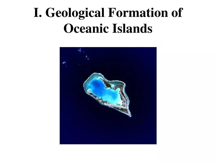
I. Geological Formation of Oceanic Islands. I. Geological Formation of Oceanic Islands. A. What is an oceanic island?. Oceanic Island:. No direct, terrestrial connection to continent (now or in the past); Usually separated from continent by deep ocean. Usually formed by volcanic activity;.

E N D
I. Geological Formation of Oceanic Islands A. What is an oceanic island?
Oceanic Island: • No direct, terrestrial connection to continent (now or in the past); • Usually separated from continent by deep ocean. • Usually formed by volcanic activity;
I. Geological Formation of Oceanic Islands What is an oceanic island? Lithosphere and Plate Tectonics
Cutaway Diagram of the Earth • Inner Core • Radius ~1255 km • Solid Iron • ~ 4100˚C • Rotates W to E
Cutaway Diagram of the Earth • Outer Core • ~ 2,220 km thick • Liquid Iron-Nickel • ~ 4100˚C • Rotates E to W • Rotation generates earth’s magnetic field
Cutaway Diagram of the Earth • Mantle • ~2,800 km thick • Mostly solid (“silly putty”) • Mg/Fe/SiOx (Olivine) • ~1000-3,500˚C • Heat generated by high pressure and radioactive decay (U, Th, K)
Cutaway Diagram of the Earth • Upper Mantle • Outer Mantle • ~ 30 to 70 km deep • Solid rock • Asthenosphere • ~70 to 300 km deep • soft - flows slowly
Cutaway Diagram of the Earth • Crust • ~ 5-50 km thick • Solid, brittle rock
Two Types of Crust: • Continental crust • Oceanic crust Continental crust Ocean Oceanic crust
Continental Crust: • Forms the continents • 20 - 70 km thick (average ~ 30 km) • Granite (Al / SiOx) = metamorphic rock • Relatively low density (~2.7 g/cc) = buoyant • Surface averages ~ 125 m above sea level • Old (up to 3.8 billion years old) • Covers ~ 35% of earth’s surface Continental crust Ocean Oceanic crust
Oceanic Crust: • Forms the deep sea floor • 5 - 10 km thick (average ~ 7 km) • Basalt (Fe / Mg / Al / Na / Ca / SiOx) = igneous rock • Relatively dense (~ 3 g/cc) = negatively buoyant • Surface averages ~ 4 km below sea level • Young ( ≤ 160 - 190 million years old) • Covers ~ 65% of earth’s surface Continental crust Ocean Oceanic crust
Lithosphere = Crust + Solid Outer Mantle(from Greek: Lithos = rocky) • 70-250 km thick • Thicker under continents • Thinner under oceans • Broken into many plates • Lithospheric plates “float” on soft asthenosphere* • *Asthenosphere: From the Greek, asthenes = weak
Tectonic Plates of the World Source: Wikipedia http://en.wikipedia.org/wiki/Plate_tectonics
Continental Drift: Continents have moved over the earth’s surface during geological time. • First proposed by German astronomer / meteorologist • Alfred Wegener circa 1910-12. • Highly controversial; ridiculed, esp. in U.S. • Finally accepted by mainstream geology in 1960s. Alfred Wegener 1880-1930
Continental drift incorporated into modern theory of Plate Tectonics*: *From the Greek: τεκτονικός "pertaining to building” Scientific theory describing large scale movements of the Earth’s lithospheric plates Drifting continents have had a major impact on the distribution and evolution of animals and plants over the past 200+ million years.
Plate Tectonics and Oceanic Island Formation (Highly simplified!)
Convection Currents in Mantle Bring Molten Rock (Magma) Toward Lithosphere.
Divergent Plate Boundary • Magma pushes up from mantle through • lithospheric plate • Forms new oceanic crust • Pushes plates apart (~5 cm / yr) • = Sea Floor Spreading Center Formation of Oceanic Crust Animation http://www.wwnorton.com/college/geo/egeo/flash/2_7.swf
Mid-ocean ridge system develops where sea-floor spreading occurs.
Volcanic activity at mid-ocean ridge can form ocean islands (e.g., Iceland).
Movement of lithospheric plate that includes continental crust results in continental drift. Click Here to Play Seafloor Spreading Animation http://www.wwnorton.com/college/geo/egeo/flash/2_5.swf
Movement of lithospheric plates caused breakup of Pangea Super-continent ~300 million years ago Click to play Animation http://sos.noaa.gov/videos/Scotese.mov
Convergent Plate BoundaryConvergence of two oceanic plates: Denser plate sinks under lighter plate = subduction zone. Source: Wikipedia http://en.wikipedia.org/wiki/Plate_tectonics
Click Here to Play Subduction Animation http://www.wwnorton.com/college/geo/egeo/flash/2_9.swf
Convergence of Crustal Plates withSubduction zone results in earthquake and volcanic activity (e.g., Pacific Rim of Fire). Source: Wikipedia http://en.wikipedia.org/wiki/Plate_tectonics
Volcanic Activity at Tectonic Plate Boundaries Source: USGS http://pubs.usgs.gov/gip/hawaii/page10.html
Volcanic activity at subduction zone can form oceanic islands(e.g., Aleutians; Lesser Antilles). Source: Wikipedia http://en.wikipedia.org/wiki/File:Japan_separation.png
In areas where lithospheric plate is thin, magma plume from mantle can push up through plate, forming a “hot spot.” Hotspot Volcano Animation
Map of hot spots http://www.math.montana.edu/~nmp/materials/ess/geosphere/advanced/activities/hotspots/index.html
Review Most oceanic islands formed by volcanic activity: 1. along mid-ocean ridge 2. along subduction zone at convergent boundary of two crustal plates 3. at “hot spot” in middle of crustal plate
Eventually, as volcanic island erodes and aging oceanic crust becomes more dense, volcanic cone submerges to form undersea mountain = seamount (rounded top) or guyot (flat top); • Oceanic islands estimated to last only • 5-10 million years.
Geological Formation of Oceanic Islands A. What is an oceanic island? B. Lithosphere and Plate Tectonics C. Formation of the Hawaiian Island Chain
Hawaiian Islands Source: USGS http://pubs.usgs.gov/gip/hawaii/page05.html
Northwest Movement of Pacific Plate Over Fixed Hawaiian Hot Spot Source: USGS http://pubs.usgs.gov/gip/hawaii/page12.html
Ages of Hawaiian Islands Source: http://volcano.und.edu/vwdocs/vwlessons/hotspots.html
Hawaiian Island -Emperor Seamount ChainEmperor Seamount chain extends north from Hawaiian islands
Conventional plate tectonic theory assumes that lithospheric plates move, while hotspots are stationary; as plate moves over hotspot, volcano goes inactive.
However, recent evidence suggests that hotspots can move.Emperor Seamount chain may have formed by hotspot that moved south as Pacific plate moved northwest.
Geological Formation of Oceanic Islands A. What is an oceanic island? B. Lithosphere and Plate Tectonics C. Formation of the Hawaiian IslandChain D. Formation of Bermuda
Geological Formation of Bermuda (1) 110 Million Years Ago (MYA): Volcanoes along Mid-Atlantic Ridge; Seafloor spreading moved volcanic cones NW at 2 cm/year; 30-50 MYA: Second phase of volcanic activity – probably due to hotspot -three volcanic cones formed Bermuda Rise. Bermuda Rise continued to migrate NW; One volcanic cone emerged above sea level (= 1,000 meter high mountain?);
Geological Formation of Bermuda (2) 30 MY to present:Bermuda Rise continued moving to present location, 32° 10-30’N ~ 1000 km east-southeast of Cape Hatteras, NC ~ 1000 km southeast of Connecticut coast Bermuda Rise comprises three seamounts (relicts of volcanic cones): Argus Bank, Challenger Bank, and Bermuda Seamount (= Bermuda Pedestal);
Bermuda Sea Mount http://topex.ucsd.edu/marine_topo/gif_topo_track/topo8.gif Mid-Atlantic Ridge San Salvador Bahama Banks
Bermuda Rise http://hoopermuseum.earthsci.carleton.ca/Bermuda/Geology/BERM5-1A.HTML
Geological Formation of Bermuda (3) • Top of Bermuda Seamount exposed (eroded) and submerged several times with rising and falling sea levels; • Seamount capped with limestone precipitated from seawater (oolitic* limestone) and laid down by corals and other marine organisms (biogenic limestone) while submerged. *Oolitic: “Egg-stone”- formed from ooids (spherical grains with concentric layers; 0.25-2mm in diameter) Ooids
Satellite Image of Bermuda Source: http://earthobservatory.nasa.gov/images/imagerecords/7000/7397/bermuda_l7_1999226_lrg.jpg
Geological Formation of Bermuda (4) Coral reefs form rim around the Bermuda Platform. Islands of Bermuda are primarily “fossilized” sand dunes (aeolian* limestone) rising above limestone platform. *Aeolian: Wind-blown (From Aeolus, the Greek God of Wind) Reference: The Geology of Bermuda (Bermuda Zoological Society, GEO-01, 2006) http://www.gov.bm/portal/server.pt/gateway/PTARGS_0_2_11280_207_227543_43/http%3B/ptpublisher.gov.bm%3B7087/publishedcontent/publish/new_min_of_environment/environmental_protection___project_nature_fact_sheets/the_geology_of_bermuda_0.pdf