Download
1 / 22
230 likes | 910 Views
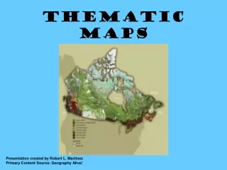
Project 5 Thematic Maps Aaron Henning & Carl Sherlock Thematic Maps Basics Transfer geographic data into geographic information Highlight one attribute’s geographic distribution Single purpose or “theme” in mind Review: Reference maps portray many attributes and features

E N D
Project 5Thematic Maps Aaron Henning & Carl Sherlock
Thematic Maps Basics • Transfer geographic data into geographic information • Highlight one attribute’s geographic distribution • Single purpose or “theme” in mind • Review: Reference maps portray many attributes and features
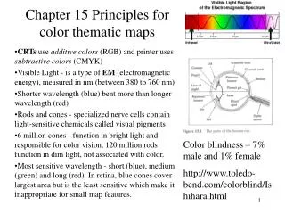
Thematic Maps • Use abstract, graphic symbols that represent the quantities and qualities that make locations meaningful • The use of colors and symbols to project attribute data • Attribute data examples: density, counts, rates, etc. • Cynthia Brewer’s presentation
Thematic Mapping • Counts • Showing a symbol for each individual or group of individuals • Fails when many individuals or groups are present and/or when location is unknown
Thematic Mapping • Porportional Symbol Maps • Also called graduated symbol maps • They represent classes of counts not individual counts • Useful for counts that lack location
Thematic Mapping • Chloropleth – “place” & “value” • Involves coloring geographic areas to represent categories of rates or densities • Most common type of thematic map
Thematic Mapping Pie Chart • Rates and densities • Simply one count divided by another count • In densities, the divisor is the magnitude of a geographic area • Can be in various formats Bar Graph
Starting the Project • Go to factfinder.census.gov • Left side menu, hover cursor over “DATA SETS” • Click on “Decennial Census”
Making sure you are selecting “Census 2000 Summary File 1”, choose “Thematic Maps” on right hand menu • Select “county” under geographic type • Select your state, then select your county, and hit “Next” • This will display all of the data themes that can be displayed on a map pick one and click “Show Result”
Directly above map where it says “Display map by:”, select “Census Tract” from drop-down menu • Adjust zoom and pan to make data as visible as possible
At top of left side menu under “Change…”, select “data classes” • From here you can change classing method, color scheme, and number of classes
Classing Methods Review • Quantile (percentile) • Equal number of featuresin each class • Equal Interval • Equal range of valuesin each class • Natural Breaks • Divides features and/or range of values according to pre-existing groupings or divisions
When finished customizing, right click map and select “Save picture as...” (repeat for legend)
You have now successfully found and downloaded all data for your first map • For this project, you need a total of 3 maps • At least one needs to be of ACS Data • From FactFinder homepage, hover over “Data Sets” and click on “American Community Survey” and follow same process
Think about this, it will help you with the write-up • Take a moment to analyze your map – why is the data how it is? • Why does the tract that corresponds to campus and downtown have the lowest percent of persons under 18? Map 1: Percent Persons Under 18 Years of Age
Finding Map Scale • In bottom left corner of your map image, it will tell you distance across (Dg) • The actual width of the image is ~6” (Dm) • Remember the formula? S = Dm / Dg
Review • Thematic Mapping • Attribute data transformed into useful geographic information • Designed with a central purpose or theme • Different types of data are represented in different ways
References • Baxter, Ryan. Census Mapping and Thematic Maps. GEOG 121 Lecture. 11/20/06 • Brewer, Cynthia. Cartographic Inspirations for Designing Better Data Visualizations. GEOG 121 Guest Presentation. 10/11/06 • Census Bureau FactFinder. Accessed 11/20/06. http://factfinder.census.gov • ESRI Virtual Campus: Module 6. Accessed 11/19/06. http://training.esri.com • The Pennsylvanian Marketing and Planning Center. Accessed 11/20/06. http://www.mapcenter.org/index.html
Help • Aaron Henning – amh334@psu.edu • Carl Sherlock – cfs5000@psu.edu • http://personal.psu.edu/cfs5000/geog121_lab5.html • Course Example • http://www.geog.psu.edu/courses/geog121/projects/proj5_example.html