Download
1 / 29
410 likes | 844 Views
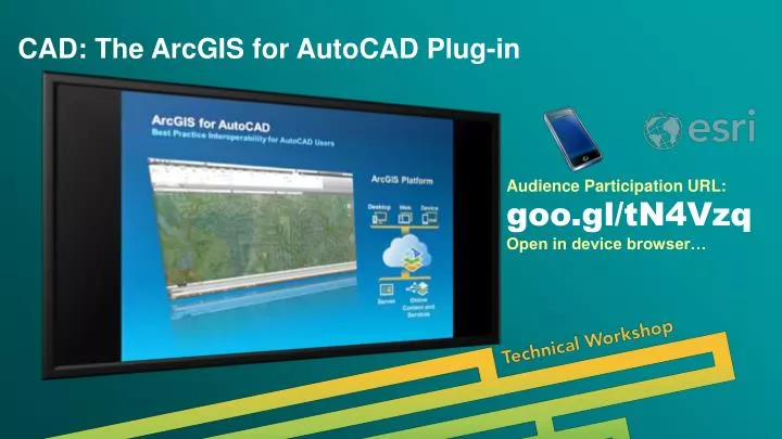
CAD: The ArcGIS for AutoCAD Plug-in. Audience Participation URL: goo.gl/tN4Vzq Open in device browser…. CAD: The ArcGIS for AutoCAD Plug-in. Don Kuehne, Product Manager Karen Hodge, Lead Developer. Resources. ArcGIS for AutoCAD. Samples, Blogs, Documentation, Training, Tips….

E N D
CAD: The ArcGIS for AutoCAD Plug-in Audience Participation URL: goo.gl/tN4VzqOpen in device browser…
CAD: The ArcGIS for AutoCAD Plug-in Don Kuehne, Product Manager Karen Hodge, Lead Developer
Resources ArcGIS for AutoCAD Samples, Blogs, Documentation, Training, Tips… • GIS CAD Interoperability Blog : http://giscadblog.blogspot.com/ • GISCADChannel : https://www.youtube.com/user/GISCADChannel • Esri CAD Resource Center: http://resources.arcgis.com/en/communities/cad-integration/ • ArcGIS for AutoCAD Support Forums • Esri Technical Support • Repeat of this Session: Wednesday 14A (3:15 – 4:30 pm) • Using CAD in ArcGIS: Thursday Room 8 (8:30 - 9:45am) More Services, More Access….
ArcGIS Supports the Enterprise Enterprise Integration Public Engagement WorkAnywhere Executive Access Knowledge Workers Web GIS ArcGIS Making Mapping and GIS Available Across Your Organization CAD/GIS Professionals Transforming the Role of GIS
ArcGIS for AutoCADBest Practice Interoperability for AutoCAD Users ArcGIS Platform Desktop Web Device Server Online Content and Services CAD: The ArcGIS for AutoCAD Plug-in
ArcGIS for AutoCAD What is it? Client of ArcGIS System Web Services Edits ArcGIS Data ArcGIS Data inside DWG Files Software User Interfaces Ribbon, Panels, Table Viewer, Attribute Dialog, Commands… AutoLISP API ArcGIS for AutoCAD CAD: The ArcGIS for AutoCAD Plug-in
ArcGIS for AutoCAD Implementation Patterns File, Services, Shared Platform …System Web GIS Server Centric File Based Web Centric
Workflow Patterns Supporting Common Daily Workflows ConsultantsSubmittal Standards Enterprise Editing Disconnected/Field Editing
Agenda Demonstrations What we will build We will map our meeting room • Use Esri Services in AutoCAD • Create AutoCAD Drawings with ArcGIS Data “Inside” • Edit ArcGIS Web Feature Services with AutoCAD • Enterprise (Desktop/Web/Mobile) Editing • Disconnected Feature Service Editing (Long Transaction) Best Practice Interoperability for ArcGIS and AutoCAD
DEMO Esri Web ServicesLocation, Maps, Imagery…Features Desktop Web Device Web GIS ArcGIS for AutoCAD Server Online Content and Services CAD: The ArcGIS for AutoCAD Plug-in
Review Esri Web Services What we built together • Esri Maps: World Topographic, World Imagery… Soils, Survey Control… • Esri World Locator Service • Esri Coordinate System • ArcGIS Global User Community… Best Practice Interoperability for ArcGIS and AutoCAD
DEMO ArcGIS Data Inside AutoCAD FilesDirect Read / Data Migration Desktop Web Device ArcGIS for Desktop Server ArcGIS for AutoCAD .DWG with ArcGISFeature Classes CAD: The ArcGIS for AutoCAD Plug-in
Review ArcGIS Data Inside AutoCAD Files What we built together • Esri Coordinate System • ArcGIS Feature Classes from Entities • ArcGIS Feature Attributes • Standard AutoCAD Geometric Editing • ArcMap Reads as Native GIS Data Sets • Appended CAD Data… Shared with Enterprise Best Practice Interoperability for ArcGIS and AutoCAD
ArcGIS data in AutoCAD files (MSC) Feature Classes Attributes Coordinate System Better than Shapefiles… EXPORT TO CADCreate and Append to CAD Files ArcMap DWG CAD: The ArcGIS for AutoCAD Plug-in
DEMO Feature Service EditingArcGIS for AutoCAD Desktop Web Device Web GIS ArcGIS for AutoCAD Server Online Content and Services CAD: The ArcGIS for AutoCAD Plug-in
Review Feature Service Editing What we built together • Connected to ArcGIS Server(s) • GIS Schema Generated Automatically • Editing with AutoCAD (Adding, Deleting, Modifying…) • Edits on “ESRI_” AutoCAD Layer • Optional “ESRI_” Point Symbols • SYNCRONIZE with ArcGIS Server Best Practice Interoperability for ArcGIS and AutoCAD
DEMO Template Files / GIS SubmittalsArcGIS for AutoCAD Desktop Web Device Web GIS ArcGIS for AutoCAD Server Online Content and Services ArcGIS for AutoCAD CAD: The ArcGIS for AutoCAD Plug-in
DEMO Template Files / GIS SubmittalsArcGIS for AutoCAD Desktop Web Device Web GIS ArcGIS for AutoCAD Server Online Content and Services ArcGIS for AutoCAD CAD: The ArcGIS for AutoCAD Plug-in
DEMO Enterprise Feature Editing / Collaboration Enterprise Integration Public Engagement WorkAnywhere Executive Access Knowledge Workers Web GIS ArcGIS Making Mapping and GIS Available Across Your Organization ArcGIS for AutoCAD Transforming the Role of GIS
Audience Participation URL: goo.gl/tN4Vzq Open in browser on your device…
Review Enterprise Feature Editing / Collaboration What we built together • Maps are Authored with ArcMap • Maps are Served by ArcGIS for Server • Same Maps/Services Consumed with Many Clients… • ArcGIS for AutoCAD, ArcMap, WebMaps, WebApps… Collector… your apps Best Practice Interoperability for ArcGIS and AutoCAD
DEMO Disconnected / Long TransactionArcGIS for AutoCAD Desktop Web Device Web GIS ArcGIS for AutoCAD Server Online Content and Services ArcGIS for AutoCAD CAD: The ArcGIS for AutoCAD Plug-in
Summary ArcGIS for AutoCADWhat we did • Used Esri Services in AutoCAD • Created ArcGIS Data “Inside” AutoCAD Drawings • Edited ArcGIS Feature Services with AutoCAD • Performed Enterprise (Desktop/Web/Mobile) Editing • Edited Feature Services Disconnected (Long Transaction)
Quick Facts ArcGIS for AutoCAD 350 • Supports Windows 32/64 AutoCAD 2013-2014 (*2015) • Civil 3D, Map 3D… etc • For AutoCAD (2010-2012) use : AFA 300 Sp1 • ArcGIS 10.1+ • Download Now: http://www.esri.com/software/arcgis/arcgis-for-autocad More Services, More Access…. Transforming the Role of GIS
Road Ahead ArcGIS for AutoCAD 400+ • Share CAD using ArcGIS Online • More Esri Services in AutoCAD • Elevation • Analysis • ArcGIS Online Hosted Feature Services More Services, More Access…. Transforming the Role of GIS
Feedback Thank you… We hope you had an EXCELLENT experience… Please fill out the session survey: First Offering ID: 1187 Second Offering ID: 1310 Online – www.esri.com/ucsessionsurveys Paper – pick up and put in drop box CAD: The ArcGIS for AutoCAD Plug-in
Translation and Conversion Geometric Manipulation File and Data Aggregation Filtering Feature Building/Creation/Reconstruction On-The-Fly Data Interpretation Geoprocessing Integration BIM (IFC), REVIT Plug-in Data Interoperability Extension 23445 23437 CAD: The ArcGIS for AutoCAD Plug-in
Geoprocessing ANALYSIS: BUFFER, FREQUENCY, FEATURE TO POLYGON, INTERSECT, SPATIAL JOIN…etc... DATA MIGRATION: COPY FEATURE, FEATURE CLASS TO FEATURE CLASS, APPEND, MERGE, CAD TO GEODATABASE, FEATURE to POLYGON, IMPORT CAD ANNOTATION… WRITE TO CAD FILES: EXPORT TO CAD CAD and Geoprocessing CAD: The ArcGIS for AutoCAD Plug-in